Map found on Wikimedia Commons
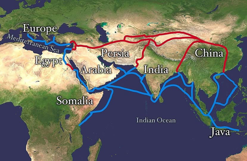
That red line snaking across Central Asia and the blue one weaving through the Indian Ocean do not look like much at first glance. But together they represent one of the most transformative networks in human history: the Silk Road.
Not one road, and not just about silk. The Silk Road was a sprawling web of overland and maritime trade routes connecting China all the way to Europe, and it was the ancient world’s version of the internet.
The Land Route: Deserts, Mountains, and Merchants
The red line on this map traces the classic overland corridor, running westward from China through Persia, skirting the edges of Arabia, and eventually reaching the Mediterranean and European markets.
Caravans loaded with silk, spices, paper, and porcelain would brave punishing terrain across the steppes and mountain passes of Central Asia.
This was not a quick trip. A full journey could take years, and most merchants only covered one leg of the route, passing goods from hand to hand like a relay race spanning continents.
The Maritime Route: Wind, Water, and Monsoons
The blue lines tell an equally remarkable story. Arab, Indian, Malay, and Chinese sailors had cracked the code of the monsoon winds by the first century CE, using seasonal weather patterns to sail predictably across the Indian Ocean.
Routes linked China and Java to India, Arabia, the East African coast near Somalia, and up through the Red Sea to Egypt and the Mediterranean.
This sea route was faster and could carry far more cargo than any camel caravan. It also gave rise to extraordinary cosmopolitan port cities along the way, places where languages, religions, and cuisines blended into something entirely new.
More Than Trade
What moved along these routes went far beyond commodities. Buddhism spread from India into China. Islam traveled with Arab merchants into Southeast Asia. Paper and printing technology crept westward toward Europe. Plague, unfortunately, also made the journey.
The Silk Road was essentially the world’s first globalisation event, reshaping cultures on every continent it touched long before anyone coined the phrase “global economy.”
Why It Still Matters
Understanding this map gives you a shortcut to understanding why so many modern geopolitical flashpoints exist where they do. The same corridors that once carried silk now carry oil pipelines, fiber optic cables, and infrastructure projects. China’s Belt and Road Initiative is, in many ways, a deliberate echo of what you are looking at right now.
History does not repeat itself, but it certainly likes familiar geography. Next time you hear about tensions in the Strait of Hormuz or investment in East African ports, picture this map. The routes change. The logic rarely does.
Help us out by sharing this map: