Map from the Atlas of the Historical Geography of the United States (1932)
These fascinating maps from the 1932 Atlas of the Historical Geography of the United States tell one of the most dramatic stories in American history: how our vast continent became dramatically smaller through revolutionary advances in transportation technology.
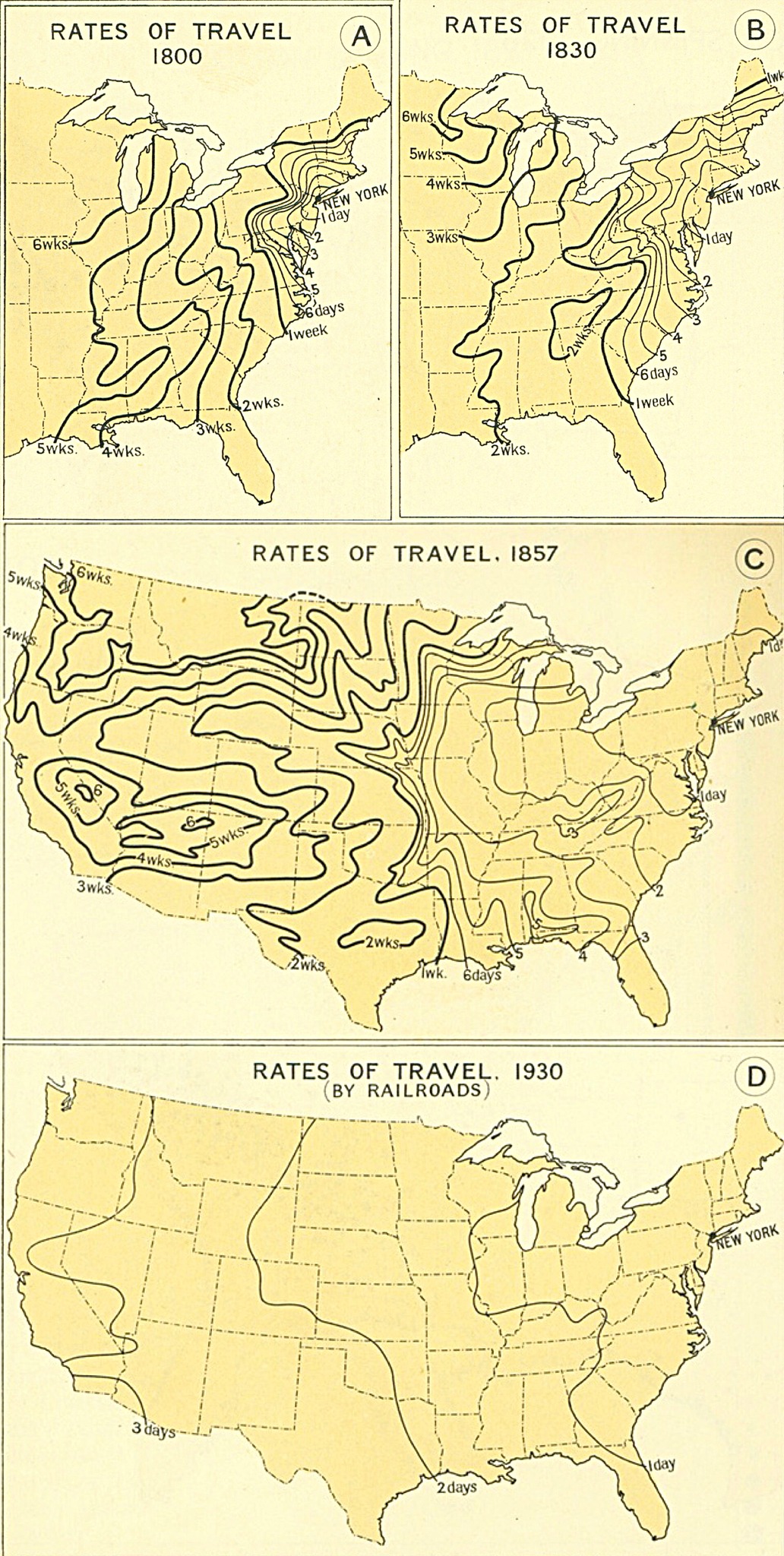
The Walking and Wagon Era (1800)
In 1800, America was truly enormous in terms of travel time.
From New York City, it took six grueling weeks to reach the frontier regions of what we now call the Midwest. The western territories were essentially unreachable for most people, requiring months of dangerous overland travel.
This map shows an America where regional isolation was the norm and cross-country communication moved at the speed of horse and foot.
Early Transportation Improvements (1830)
By 1830, we see the first major improvements.
Canal systems like the Erie Canal began connecting inland areas to coastal cities, while better roads shortened some journey times. Travel to areas that once took six weeks now required only four to five weeks.
While still incredibly slow by today’s standards, this represented a meaningful improvement that began knitting the young nation together economically and culturally.
The Railroad Revolution Takes Hold (1857)
The 1857 map reveals the transformative power of the railroad. Suddenly, vast swaths of the continent became accessible within days rather than weeks.
The expanding rail network created corridors of rapid movement, dramatically shrinking effective distances.
Areas that required weeks of travel in 1800 could now be reached in mere days, fundamentally changing how Americans thought about distance and possibility.
The Mature Railroad Network (1930)
By 1930, the railroad network had reached full maturity, creating an America where you could travel from New York to most of the country within just a few days.
The final map shows a nation truly unified by steel rails, where the vast distances that once separated regions had become manageable journeys. This infrastructure laid the foundation for our modern economy and culture.
The Dawn of Aviation (1930)
While the 1930 railroad map shows the peak of ground transportation, commercial aviation was just beginning that same year. Flying was expensive, limited to short routes between major cities, and still required two days for transcontinental travel with multiple stops.
However, aviation would soon shrink America even more dramatically than railroads had. Within two decades, the cross-country journey that took weeks by wagon in 1800 and days by train in 1930 would take just hours by air. The 1930 map captures a unique moment: the peak of one transportation era just as the next revolution was about to begin.
Why This Matters Today
These maps illustrate something profound about human progress. In just 130 years, Americans transformed their relationship with space and time through technological innovation. The same journey that took pioneers weeks of hardship became a comfortable few days by train.
This transportation revolution enabled everything from national markets to shared cultural experiences. It allowed people to maintain family connections across vast distances and made possible the great internal migrations that shaped modern America.
Looking at these maps reminds us that the challenges we face today with digital connectivity, climate change, and global coordination are part of a long human tradition of using technology to shrink distances and bring people together.
Help us out by sharing this map: