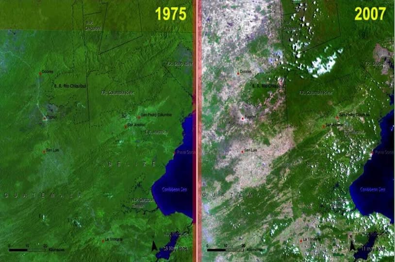
Map by NASA/UNEP/CATHALAC
This striking side-by-side satellite image tells a story that no bar chart could ever quite capture.
On the left, Belize in 1975: a dense, vivid carpet of tropical green. On the right, the same country in 2007: patchier, browner, and unmistakably changed. Thirty-two years. One powerful image.
The Green Is the Point
That rich green covering nearly the entire 1975 frame isn’t just pretty. It represents one of Central America’s most biodiverse forest systems, home to jaguars, tapirs, hundreds of bird species, and some of the healthiest coral reef systems in the Western Hemisphere, just off that Caribbean coastline you can see to the right.
Belize was, for a long time, a conservation success story relative to its neighbours. Much of that is thanks to low population density and a government that designated large protected areas, including the Chiquibul National Park that’s visible in the north of both images.
So What Happened Between 1975 and 2007?
A few things converged. Agricultural expansion, particularly sugar cane and citrus farming, pushed into forested areas. Population growth in border regions with Guatemala added pressure.
Illegal logging, despite protections, remained a persistent issue. And cattle ranching, a driver of deforestation across all of Latin America, quietly chewed through forest edges year by year.
The lighter, brownish tones spreading across the 2007 image are largely cleared land. Once the forest goes, the soil degrades quickly in tropical climates, which is why so much of what replaced the trees looks scrubby and pale from orbit.
Why Should You Care?
Tropical forests are not just a “nice to have.” They regulate rainfall patterns across entire regions, store enormous amounts of carbon, and support food systems that millions of people depend on. When Belize loses forest, its neighbours feel it too.
The good news? Belize has since strengthened its protected area legislation and, as of the early 2020s, has one of the highest percentages of protected land of any country in the Americas, covering over 40% of its territory. Progress is real, even if the damage shown here took decades to begin reversing.
The Bigger Picture
Maps like this one are genuinely useful because they bypass argument and just show you the thing. No commentary needed on the 1975 frame versus 2007. Your eyes do the work.
If a picture is worth a thousand words, a before-and-after satellite image of a disappearing rainforest might be worth a thousand policy debates.
The forest was there. Then it wasn’t. Now the question is whether what remains can be protected for good.
Help us out by sharing this map: