Map found on Reddit
If you’ve ever looked at Brazil and thought “big country, diverse people,” this map will show you just how true that is, and where.
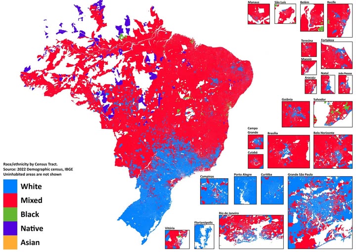
Created from Brazil’s 2022 Demographic Census by IBGE (the country’s official statistics agency), this map colors every census tract by its dominant racial or ethnic group: White (blue), Mixed or pardo (red), Black (green), Native (dark purple), and Asian (orange).
The Amazon Is a World of Its Own
That enormous stretch of deep purple and blue across the north and west? That’s the Amazon basin, home to Brazil’s indigenous Native populations.
Hundreds of distinct peoples live across these territories, many in legally protected lands. The sheer scale of Native presence here is striking, and a reminder that this land has been inhabited for thousands of years before any colonial map was drawn.
The Northeast Runs Red
Across the vast northeastern interior, red dominates almost completely. This reflects Brazil’s pardo population: people of mixed African, European, and indigenous heritage who make up the largest single group in Brazil overall.
Cities like Fortaleza, Teresina, and Recife show this clearly in the inset maps: dense, red urban cores with very little variation.
The South Tells a Different Story
Drop your eyes to the bottom third of the map, and the color shifts dramatically to blue. The southern states of Rio Grande do Sul, Santa Catarina, and Paraná were heavily settled by German, Italian, Polish, and other European immigrants from the mid 1800s onward.
The result today is a predominantly White population that stands visually apart from the rest of the country.
Cities Are the Most Interesting Part
The urban insets are where things get really nuanced. São Paulo, Rio de Janeiro, and Curitiba all show dramatic patchwork patterns: wealthy, predominantly White neighborhoods sitting right next to heavily Mixed or Black communities.
Salvador in the northeast stands out as one of the Blackest cities in the Americas outside Africa, reflecting its history as a major hub of the transatlantic slave trade.
Brasília, the planned capital, shows an almost textbook segregation pattern: a blue administrative core surrounded by red satellite cities where lower-income workers historically settled.
Why This Matters
Race and geography in Brazil are not accidental. They reflect centuries of colonization, slavery, immigration policy, and economic inequality. This single map encodes all of that history into color. Understanding where people live (and why) is the first step toward understanding the country itself.
Brazil is often celebrated for its racial mixing, and rightly so. But this map reminds us that diversity does not always mean integration.
Help us out by sharing this map: