Map from RMO
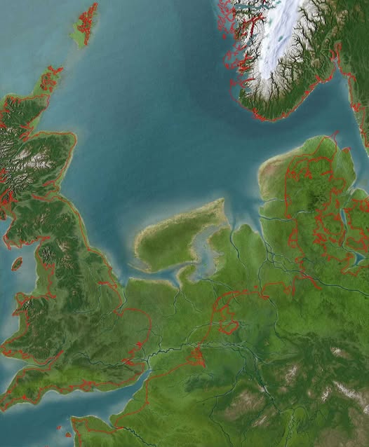
Look at the map above, and something feels slightly off. Britain is connected to Europe. The North Sea is mostly dry land. Rivers snake across a vast, green plain.
This is Doggerland, the prehistoric landmass that once joined Britain to continental Europe, and around 10,000 years ago, it was very much alive.
We are looking at a world our ancestors actually walked across.
Who Lived There?
Doggerland was not some barren wasteland. It was rich, fertile territory, filled with rivers, wetlands, and forests. Mesolithic hunter-gatherers roamed its plains hunting deer and wild boar, fishing its rivers, and gathering along its coasts. By the standards of the time, this was prime real estate.
The central elevated landmass visible in the map, sometimes called Dogger Island or Dogger Hills (the ancestor of today’s Dogger Bank), would have been one of the last areas to remain above water as sea levels climbed.
Why Did It Disappear?
At the end of the last Ice Age, the massive ice sheets covering much of the northern hemisphere began to melt. Sea levels rose globally, gradually drowning the low-lying plains of Doggerland over thousands of years.
The process accelerated dramatically around 6,200 BCE when a catastrophic submarine landslide off the coast of Norway, known as the Storegga Slide, triggered a massive tsunami that likely devastated whatever communities remained on the shrinking land.
By around 6,500 years ago, Doggerland was gone. Britain became an island, and the world map we recognise today took shape.
What Have We Found?
Here is where it gets genuinely exciting. Fishermen trawling the North Sea have pulled up mammoth bones, ancient tree stumps, and even a fragment of a Mesolithic harpoon made from antler bone.
These are not fossils in the traditional sense. They are artefacts of a real human world, dragged up from the seabed.
Archaeologists and geologists are now using seismic survey data (originally collected by the oil industry) to map Doggerland in remarkable detail, piecing together its river systems, hills, and coastlines.
Why Does It Matter?
Doggerland quietly reframes our understanding of early European prehistory. The people who lived there were not isolated communities on separate islands.
They were connected, trading, moving, and sharing culture across a continuous landscape. When Doggerland drowned, it did not just swallow land. It swallowed an entire chapter of human history.
The North Sea looks unremarkable on a modern map. Knowing what lies beneath it makes it one of the most haunting stretches of water on Earth.
Help us out by sharing this map: