Map from Wikimedia Commons (public domain)
Most of us learned about the Treaty of Paris in school and moved on. But tucked inside those negotiations was a fascinating moment where France laid out its own vision for what North America should look like after the Revolutionary War, and it was very different from what actually happened.
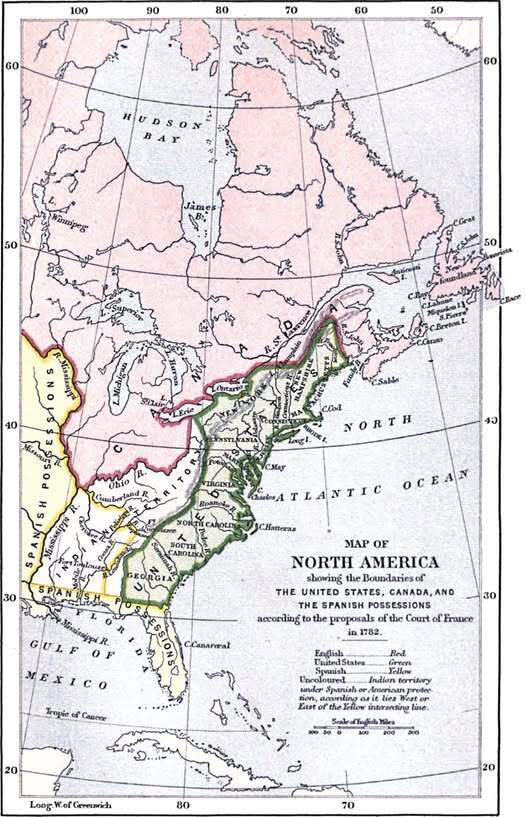
This map shows exactly that: the boundaries of the United States, Canada, and Spanish territory as proposed by the French Court in 1782.
Three Powers, Three Colors
The color coding tells the story at a glance. Red marks British (English) territory, green shows the proposed United States, and yellow covers the vast Spanish possessions stretching across the South and West.
What jumps out immediately is how squeezed the young United States appears in the French proposal. The green zone hugs the Eastern Seaboard fairly tightly. Spain dominates an enormous swath of the continent, including Florida, the Gulf Coast, and everything west of the Mississippi. Britain still holds a commanding presence to the north.
France, having backed the American Revolution financially and militarily, was now playing dealmaker, and let’s just say their proposal was not exactly generous to their American allies.
Why France Drew It This Way
France had its own strategic interests to protect. A powerful, rapidly expanding United States was not necessarily in France’s favor. Keeping the new republic contained along the coast, with Spain as a strong counterweight to the south and west, suited French geopolitical thinking nicely.
The Americans, led by Benjamin Franklin, John Adams, and John Jay, were aware of this dynamic. They actually negotiated directly with Britain behind France’s back, which ultimately produced a far more favorable deal for the United States in the final Treaty of Paris signed in 1783.
The Borders That Never Were
Perhaps the most striking feature of this map is the western boundary of the proposed United States. Under the French plan, American expansion toward the Mississippi would have been severely limited.
The Louisiana Territory and beyond would remain firmly in Spanish hands, meaning no Louisiana Purchase in 1803, no Lewis and Clark Expedition as we know it, and a dramatically different trajectory for the continent.
Why This Map Still Matters
Historical “what if” maps like this one are more than curiosities. They remind us that the borders we take for granted were not inevitable. They were fought over, negotiated, and sometimes narrowly won at the diplomatic table just as much as on the battlefield.
The United States that emerged from 1783 was larger and more sovereign than France had hoped. That outcome shaped everything that followed, and this map is a vivid snapshot of the road not taken.
Help us out by sharing this map: