Map found on Reddit
If you have ever glanced at a map of the UK and wondered why the country is carved up the way it is, this fascinating visualization has the answer.
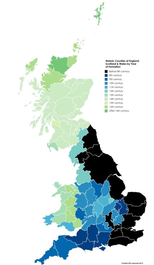
It shows the historic counties of England, Scotland, and Wales, color-coded by the century in which they were formally established, and the results are genuinely surprising.
The Ancient North
The darkest colours on the map tell the oldest story. Much of northern and eastern England is shown in deep black, representing counties that predate the 8th century. Think about that for a moment.
These administrative boundaries were being drawn before the Norman Conquest, before Magna Carta, before almost everything we associate with “modern” Britain. Counties like Northumberland and Yorkshire were already established political units when Viking longships were still a very real concern.
A Wave of Organization Moving South
What is really striking about this map is the visual pattern it creates. There is a clear sweep of progressively lighter blues moving from north to south through the English Midlands and into the southeast, representing counties formed through the 9th, 10th and 11th centuries.
The Norman Conquest of 1066 clearly accelerated a lot of administrative tidying up, as the new rulers needed to know exactly who owned what and who owed taxes to whom.
Wales Does Its Own Thing
Wales, shown largely in soft greens and teals, reflects a very different political history. Welsh counties were formalized much later, many in the 14th to 16th centuries, following the Laws in Wales Acts under the Tudors.
The patchwork of earlier Welsh kingdoms resisted standardization for far longer than their English neighbours.
Scotland: Still Being Figured Out
Scotland shimmers in the palest greens at the top of the map, indicating that many of its county structures came together after the 16th century.
Given that Scotland maintained full independence until the Acts of Union in 1707, this makes complete sense. The Highlands, in particular, were administered very loosely by any centralized standard for a long time.
Why Does Any of This Matter?
Beyond being a beautiful piece of data visualization, this map is a reminder that the political geography we take for granted has deep, uneven roots. Your county is not just a postal convenience. It is a slice of administrative history that might stretch back over a thousand years, or might be a relatively recent invention, depending on where you live.
Next time someone asks where you are from, you are not just naming a place. You are referencing a boundary decision made somewhere between the reign of Offa of Mercia and the era of the Tudors. That is quite a postcode.
Help us out by sharing this map: