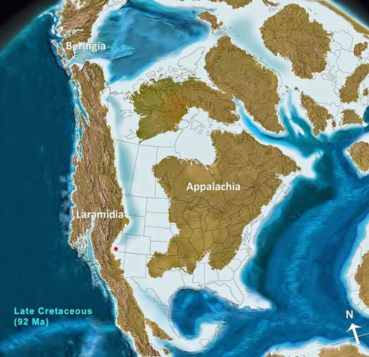
Map found on Reddit
Picture the land beneath your feet. Now imagine it completely submerged under a vast inland sea, splitting the continent in two. That is not science fiction. That was some time roughly 92 million years ago.
The Western Interior Seaway: Nature’s Great Divider
The pale blue expanse cutting through the middle of this map is the Western Interior Seaway, a shallow but enormous body of water stretching from the Arctic all the way down to the Gulf of Mexico.
It effectively sliced North America into two separate landmasses, and both had their own distinct ecosystems, climates, and creatures evolving in glorious isolation from each other.
Meet the Two Continents You Never Knew
On the western side sat Laramidia, a long, narrow strip of land roughly following today’s Rocky Mountain corridor. This is where some of the most iconic dinosaurs roamed, including T. rex, Triceratops, and many of the hadrosaurs (duck-billed dinosaurs) we know so well from fossil beds in Montana, Wyoming, and Alberta.
To the east was Appalachia, a larger, more tropical landmass covering most of what is now the eastern United States. Because it was cut off from Laramidia for millions of years, its dinosaur fauna evolved along a completely separate path.
Frustratingly for paleontologists, the eastern seaboard has far fewer exposed fossil beds, so Appalachian dinosaurs remain much more mysterious.
Beringia: The Northern Bridge
Up in the top left of the map, you can spot Beringia, the land connection between what would become Alaska and Russia. This was not always above water either, but during certain periods, it served as a crucial highway for animal migrations between Asia and North America.
Many of the dinosaur lineages we associate with North America likely crossed here from Asia, and the relationship ran both ways.
Why Does Any of This Matter?
Beyond the sheer wonder of it, maps like this one completely reframe how we think about fossil distribution.
When a paleontologist finds a dinosaur species in New Mexico but a close relative only in China, the answer often lies in ancient geography like this. Land bridges, seaways, and shifting continents were the invisible hands guiding evolution.
The red dot on the map, placed somewhere in the American Southwest, likely marks a significant fossil site, a quiet reminder that the ground in places like New Mexico and Texas is essentially an open archive of that lost world.
The Big Takeaway
North America as we know it is geologically young. The seaway drained, the landmasses merged, and the familiar continent took shape. But for tens of millions of years, two very different worlds existed side by side, separated by nothing more than a warm, shallow sea.
Help us out by sharing this map: