Map by K. Cantner, AGI / Earth Magazine
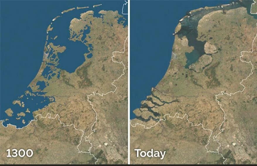
Looking at these satellite images side by side is nothing short of breathtaking. The left image shows the Netherlands as it appeared in 1300, while the right reveals the country today.
What you’re witnessing is one of humanity’s most ambitious geographic transformations, where an entire nation literally created itself from the sea.
The Great Transformation
The contrast is stark and remarkable. In 1300, much of what we now call the Netherlands was underwater or consisted of shifting marshlands and islands.
The North Sea carved deep into the landmass, creating the Zuiderzee, a massive inland sea that dominated the northern landscape. Scattered islands and waterlogged terrain made up much of the region we now know as one of Europe’s most densely populated countries.
Fast forward to today, and you’ll see solid land where water once reigned supreme. The Zuiderzee has been transformed into the Ijsselmeer, a controlled freshwater lake, while vast polders stretch across areas that were once beneath the waves.
Masters of Water Management
The Dutch didn’t just stumble into this transformation. Over seven centuries, they developed increasingly sophisticated techniques to push back the sea and claim new territory. What started with simple dikes and drainage ditches evolved into complex systems of pumps, canals, and barriers that could drain entire sea floors.
The process, called “poldering,” involves building dikes around targeted areas of water, then pumping out everything inside to create dry, usable land. These reclaimed areas, known as polders, often sit below sea level, making the Netherlands a country that exists in defiance of gravity and nature.
Engineering on an Unimaginable Scale
Perhaps the most impressive achievement visible in these images is the Afsluitdijk, the 20-mile barrier that cut off the Zuiderzee from the North Sea in 1932. This single project transformed a saltwater sea into a manageable freshwater lake and protected millions of people from flooding.
The scale becomes even more mind-boggling when you realize that about 26% of the Netherlands sits below sea level, and nearly 60% of the country would flood without human intervention. Every day, massive pumping stations work around the clock to keep the sea at bay.
A Living Testament to Human Ingenuity
These images tell a story that goes beyond geography. They show what becomes possible when a society commits to long-term thinking, invests in infrastructure, and refuses to accept the limitations imposed by nature. The Netherlands didn’t just adapt to rising seas and changing climates; they conquered them.
Today, Dutch water management expertise is exported worldwide, helping other nations prepare for rising sea levels and extreme weather. What began as a fight for survival has become a blueprint for the future.
The transformation captured in these two images represents more than land reclamation. It’s proof that with enough determination, engineering skill, and time, humans can reshape the very ground beneath their feet.
Help us out by sharing this map: