Map by JF Lepage / Wikimedia Commons
Imagine this: it’s 1750, and if you’re standing anywhere from Quebec to New Orleans, from the Great Lakes to the Rocky Mountains, you’re technically on French soil.
Welcome to New France, one of history’s most ambitious colonial experiments that most people have completely forgotten about.
The Blue Giant of North America
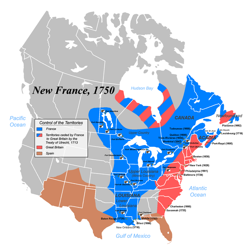
At its peak in 1750, New France wasn’t just big; it was absolutely massive.
This wasn’t some tiny coastal colony clinging to the shoreline. We’re talking about a territorial claim that stretched across what would become half of modern Canada and a huge chunk of the future United States.
The French basically looked at the continent’s river systems and said, “We’ll take all of that, merci beaucoup.”
The crown jewel was the Saint Lawrence River valley, where cities like Quebec and Montreal had already been thriving for over a century.
But the real genius move was following the waterways inland. French explorers and traders used the Great Lakes and Mississippi River system like a continental highway, establishing trading posts and settlements from the Atlantic to the Gulf of Mexico.
More Than Just Lines on a Map
What made New France different from other colonial ventures was how the French approached relationships with Indigenous peoples. Instead of the “move aside or else” strategy favored by other European powers, French colonists often integrated into existing trade networks and communities. Many French traders married into Indigenous families, creating a unique Métis culture that bridged two worlds.
This wasn’t entirely altruistic, of course. The French economy in North America ran on fur trading, and you can’t trap beavers without knowing the land and having good relationships with the people who’d been living there for thousands of years.
The Beginning of the End
By 1750, New France was already showing cracks in its foundation. The British colonies along the Atlantic coast were growing rapidly in population and economic power, while New France remained relatively sparsely populated.
The Seven Years’ War was just around the corner, and it would completely reshape the continental map.
The Treaty of Utrecht in 1713 had already forced France to hand over significant territories to Britain, including Acadia and parts of Newfoundland. You can see these “territories ceded by France” marked in red and pink on the map, representing the slow erosion of French power in North America.
Legacy of a Continental Dream
Though New France would disappear as a political entity after 1763, its cultural fingerprints remain everywhere. French place names dot the American Midwest. Quebec preserved its French character and language. The fur trading routes became the foundation for later American expansion westward.
New France reminds us that North American history could have gone very differently. For 150 years, French was just as likely to be heard in the American heartland as English. It’s a fascinating glimpse into an alternate timeline that almost was.
Help us out by sharing this map: