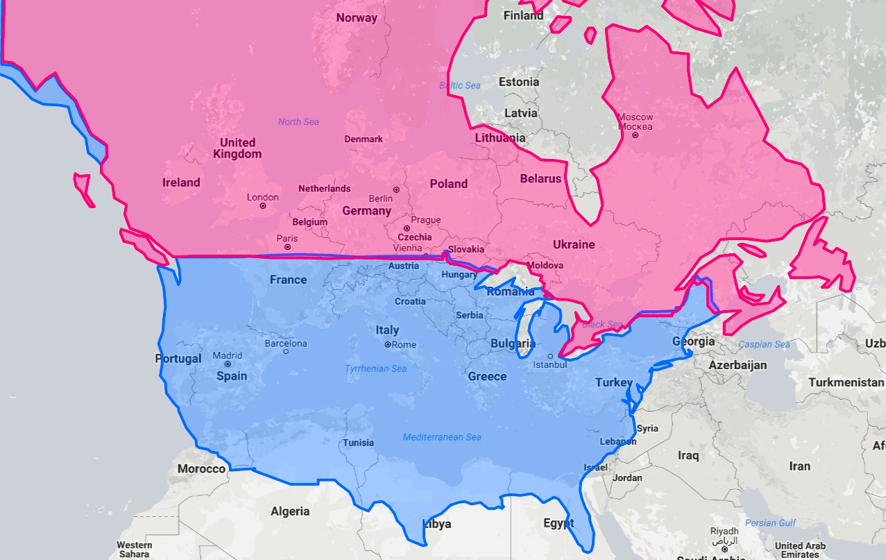
Here’s a geographical fact that might blow your mind: Miami sits at exactly the same latitude as Egypt.
San Diego shares its latitude with Morocco. If you could magically transport Detroit to Europe, it would land in southern Bulgaria, while New York City and Washington D.C. would find themselves in Turkey.
These latitude alignments reveal some genuinely surprising truths about our planet’s geography.
The Mind-Bending Reality of Latitude
The map reveals some counterintuitive geographical facts that most Americans never consider. Los Angeles, San Diego, Phoenix, and Houston are all at the same latitude as North Africa.
Even more startling, Anchorage is further south than Reykjavik, yet anyone who’s experienced an Alaskan winter versus an Icelandic one knows there’s a dramatic difference in climate severity.
Perhaps the most striking example: Reykjavik’s average temperature in January is -0.6°C (31°F) and is warmer than Boston’s average January temperature of -1.7°C (29°F) despite Reykjavik being over 20 degrees further north (64°08′N vs. 42°21′N).
The Gulf Stream Makes All the Difference
So why doesn’t Canada enjoy Mediterranean weather despite sharing similar latitudes with central Europe?
The answer lies beneath the ocean’s surface. A consensus exists that the climate of Northwest Europe is warmer than other areas of similar latitude, at least partially because of the strong North Atlantic Current.
In fact, England is about the same distance from the equator as the cold regions of Canada, yet England enjoys a much warmer climate.
If it weren’t for the warm water of the Gulf Stream, England would have a much colder climate. This oceanic conveyor belt carries warm water from the Gulf of Mexico northward and eastward, moderating European temperatures significantly.
Climate Reality vs. Latitude Expectations
The practical implications are staggering. Northern Europe is up to 9°C (16.2°F) warmer than would normally be expected without the Gulf Stream.
This explains why wine grows in southern England while Toronto, at roughly the same latitude as Monte Carlo, remains decidedly unsuitable for Mediterranean agriculture.
The milder, dry, and tropical climates of North America are found south of 40°N latitude. Much of the United States is located in these climate zones. This geographic reality has shaped settlement patterns, with most Canadian population centers clustering along the southern border where temperatures remain more temperate.
The Takeaway
This latitude map serves as a powerful reminder that geography involves far more than simple positioning on Earth’s grid.
Ocean currents, continental effects, and atmospheric patterns all combine to create the complex climate systems that determine whether a latitude produces palm trees or permafrost.
The next time you’re shivering through a Boston winter, remember that you’re experiencing weather that would be considered brutally cold by European standards, despite sharing similar coordinates on the globe.
Understanding these latitude comparisons helps explain historical settlement patterns, agricultural differences, and why your European friends might be surprised by just how cold American winters can be.
Help us out by sharing this map: