Map found here
Before social media arguments, empires had maps. And few maps caused as much international uproar as this one.
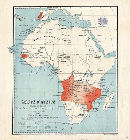
What you are looking at is Portugal’s infamous Mappa d’Africa from 1881, sometimes called the “Rose-Colored Map” or Mapa Cor de Rosa.
It is a document of extraordinary colonial ambition, and it nearly brought Portugal into direct conflict with Britain.
What Does the Map Actually Show?
The red shading tells the story. Portugal is essentially claiming a continuous belt of territory stretching from Angola on the Atlantic coast all the way across to Mozambique on the Indian Ocean, cutting clean through the middle of the continent.
The text confirms this is a map of proposed Portuguese “civilizing stations” (Estações civilizadoras portuguesas), drawn up to formalize and advertise these territorial ambitions.
Portugal had held coastal footholds in Africa for centuries, but this map represented something bolder: a land bridge connecting its two major African colonies into one unified empire.
Why Britain Said, “Absolutely Not”
There was one enormous problem. Britain had its own vision for Africa, and it ran in entirely the opposite direction.
Cecil Rhodes famously dreamed of a continuous British corridor running north to south, from Cape Town to Cairo. A Portuguese east-to-west corridor would have cut that dream clean in two.
In 1890, Britain issued what became known as the British Ultimatum, demanding that Portugal withdraw its forces from the disputed territories. Portugal, militarily and economically outmatched, backed down.
The humiliation was so severe that it destabilized the Portuguese monarchy itself, contributing to the political unrest that eventually led to the 1910 revolution and the end of the kingdom.
The Map as a Window Into Colonial Thinking
Beyond the geopolitics, this map is a fascinating artefact of how European powers genuinely perceived Africa at the time, as a largely blank space to be carved up, labelled, and projected upon.
Note how sparsely detailed the interior is compared to the coastlines, reflecting how little European explorers had actually documented the continent’s interior by 1881.
The word “civilizadoras” in the title is also worth pausing on. The framing of colonial conquest as a civilising mission was standard rhetoric of the era, used to dress up resource extraction and territorial expansion in the language of humanitarian progress.
Why It Still Matters
Maps are never neutral. This one shaped real borders, real conflicts, and real lives. Modern Angola and Mozambique both carry the legacy of the territorial logic this map represents. Next time you glance at a political map of Africa and wonder why some borders look so geometrically arbitrary, documents like this one are a big part of the answer.
Help us out by sharing this map: