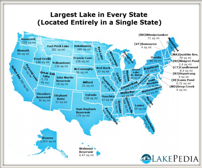
The map shown above is that of the United States. It depicts the largest lake in each U.S. state which exclusively belongs to that state.
The largest lake belonging to just one state is Utah’s Great Salt Lake, measuring 1,700 square miles (sq mi). The Iliamna Lake in Alaska comes at a close second, with an area of 1,014 square meters.
True to its name, Lake Superior is actually the largest lake in all of the U.S. and in fact, the world’s largest freshwater lake. However, this Great Lake is shared by three U.S. states: Minnesota, Wisconsin, and Michigan, in addition to the Canadian province of Ontario. The lake’s surface area is over 31,000 sq mi.
Meanwhile, the smallest lakes in America are both measuring less than 1 sq mi:
- Wahiawa Reservoir, Hawaii (0.47 sq mi)
- Lums Pond, Delaware (0.31 sq mi)
In terms of how deep each lake is, the deepest lake in the U.S. is the aptly-named Crater Lake in the state of Oregon. This lake, which sits the dormant volcano Mount Mazama, is more than 1,900 feet deep. The state of Alaska has plenty of deep lakes; the Last Frontier State owns 12 of the top 20 deepest lakes, according to a list by the now-defunct National Atlas of the United States.
Help us out by sharing this map:
You May Also Like:

From Blur to Beauty: How We Finally Saw Pluto's True Face
Napoleon's Europe: When One Man Nearly Redrew the Entire Map

What's Really Across the Ocean? The Surprising Geography That Will Change Your Beach Day Forever
When Vikings Beat Columbus: The Real Story of Who Reached America First
United States Map: Top Export Trading Partner by State
Where Europe's Young Adults Are Living With Their Parents
The Ultimate American Road Trip: Driving Through All 48 States in 113 Hours
2 thoughts on “Largest U.S. Lakes Map”