Map found on Reddit
If you glance at a modern map of Scotland, you see a unified nation. But wind the clock back to the 1100s and the picture looks dramatically different.
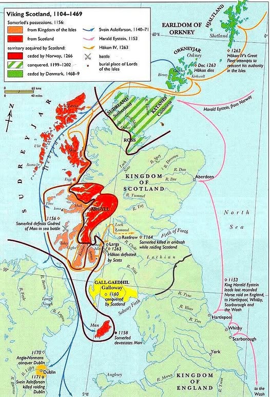
This fascinating map covers the period from 1104 to 1469, and it tells the story of a Scotland that was carved up between Norse warlords, Gaelic chiefs, and an emerging Scottish crown all fighting for the same jagged coastline.
Somerled: The Man Who Defied Everyone
The dominant figure here is Somerled, a half-Norse, half-Gaelic ruler whose territory (shown in red and orange) spread across the Western Isles and parts of the Scottish mainland.
In 1156, he defeated Godred of Man in a sea battle, cementing his grip on the Kingdom of the Isles. He was not quite Scottish, not quite Viking. He was something altogether more interesting.
His reach ran from Argyll down through the Hebridean islands, and he raided deep into Scotland before being killed in ambush around 1164 near Renfrew. A man who kept both the King of Scotland and the King of Norway guessing, right up until the end.
Norway vs Scotland: The Great Tug of War
The green hatched zones show territory that Norway eventually ceded to Scotland in 1266, and the lighter green areas were handed over by Denmark between 1468 and 1469.
Yes, Orkney and Shetland were Norwegian until the 15th century. That is not a trivial footnote. Those islands changed hands as part of a royal dowry payment, not through conquest.
King Håkon IV of Norway sailed a great fleet south in 1263 in a bold attempt to reassert Norwegian authority over the Isles. He died in Orkney that December, and with him died Norse ambitions in the region.
Harald Eystein and the Last Norse Raids on England
One of the more striking lines on the map traces Harald Eystein’s route sweeping down the east coast of England in 1153, raiding Hartlepool, Whitby, and Scarborough.
These were not small skirmishes. They were the tail end of an era when Norse fleets could appear off any coastline and demand attention.
Why This Map Matters
What this map captures beautifully is a Scotland in the process of becoming itself. The borders were not drawn by geography or ethnicity but by the outcomes of sea battles, royal marriages, and the occasional well-timed ambush. The Scotland that emerged from this period had absorbed, expelled, and negotiated with Viking power in ways that left deep marks on language, place names, and culture.
Next time someone tells you Scotland has always looked the way it does today, show them this map.
Help us out by sharing this map: