Sweden, a country roughly the size of California, once dominated much of Northern and Central Europe. This map tells the story of one of history’s most dramatic imperial expansions, when the Swedish Empire grew from a modest Scandinavian kingdom to a Nordic superpower.
From Liberation to Empire: The Vasa Foundation (1560-1611)
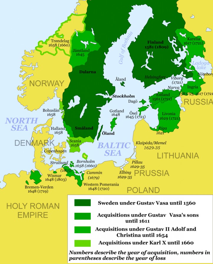
The story begins with Gustav I Vasa, who established Swedish sovereignty in 1523. The dark green territories on the map show Sweden’s core holdings under Gustav Vasa until 1560.
This wasn’t just about borders, but it was about breaking free from Danish control and creating a truly independent Swedish state.
After Gustav I Vasa was elected to the throne in 1523, he began to restore the power of the Swedish king and to organize a central administration under his direct leadership.
His reign marked the beginning of what historians call modern Sweden, setting the stage for the empire that would follow.
The Military Mastermind: Gustav II Adolf’s Conquests (1611-1632)
The medium green areas represent the territorial gains under Gustav II Adolf (1594-1632), the grandson of Gustav I. Known as the “Lion of the North,” Gustav II Adolf transformed Sweden into a military powerhouse during the Thirty Years’ War.
Gustav Adolf’s German campaign swept southward, and by late 1631 he had taken Mainz and Frankfurt am Main.
By the spring and summer of 1632, he had marched through Bavaria. His innovative military tactics and administrative reforms didn’t just win battles; they fundamentally changed how European warfare was conducted.
Adolf was committed to protecting the Lutheran confession, and his wars in the name of religion expanded Sweden’s borders and laid the foundation for Sweden as a great power.
Peak Power: The Empire at Its Greatest Extent (1654-1660)
The lightest green territories show the final expansion under Karl X Gustav. Sweden reached its largest territorial extent during this time under the rule of Charles X Gustav (1654–1660) after the Treaty of Roskilde in 1658.
Denmark–Norway was forced to give up a third of its territory to save the rest after the Northern War. The Swedish Empire now stretched from Finland in the east to parts of modern-day Germany in the south, effectively turning the Baltic Sea into what some historians call a “Swedish lake.”
The Strategic Genius Behind the Growth
What made this expansion possible wasn’t just military might. Gustav II Adolf began Parish Registration of the population, so that the central government could more efficiently tax and conscript the people.
This administrative innovation allowed Sweden to punch far above its demographic weight.
The empire’s success came from combining military innovation with smart governance. Sweden’s relatively small population (compared to France or the Holy Roman Empire) was maximized through efficient organization and superior tactics.
Legacy of the Swedish Empire
While the Swedish Empire would eventually decline in the 18th century, this map represents one of history’s most remarkable examples of how strategic leadership and military innovation can transform a small nation into a European superpower.
The territorial acquisitions shown here shaped the political landscape of Northern Europe for centuries to come.
Today, as we look at this map, it serves as a reminder that in the complex game of European politics, size isn’t everything. Sometimes, smart strategy and bold leadership can reshape an entire continent.
Help us out by sharing this map: