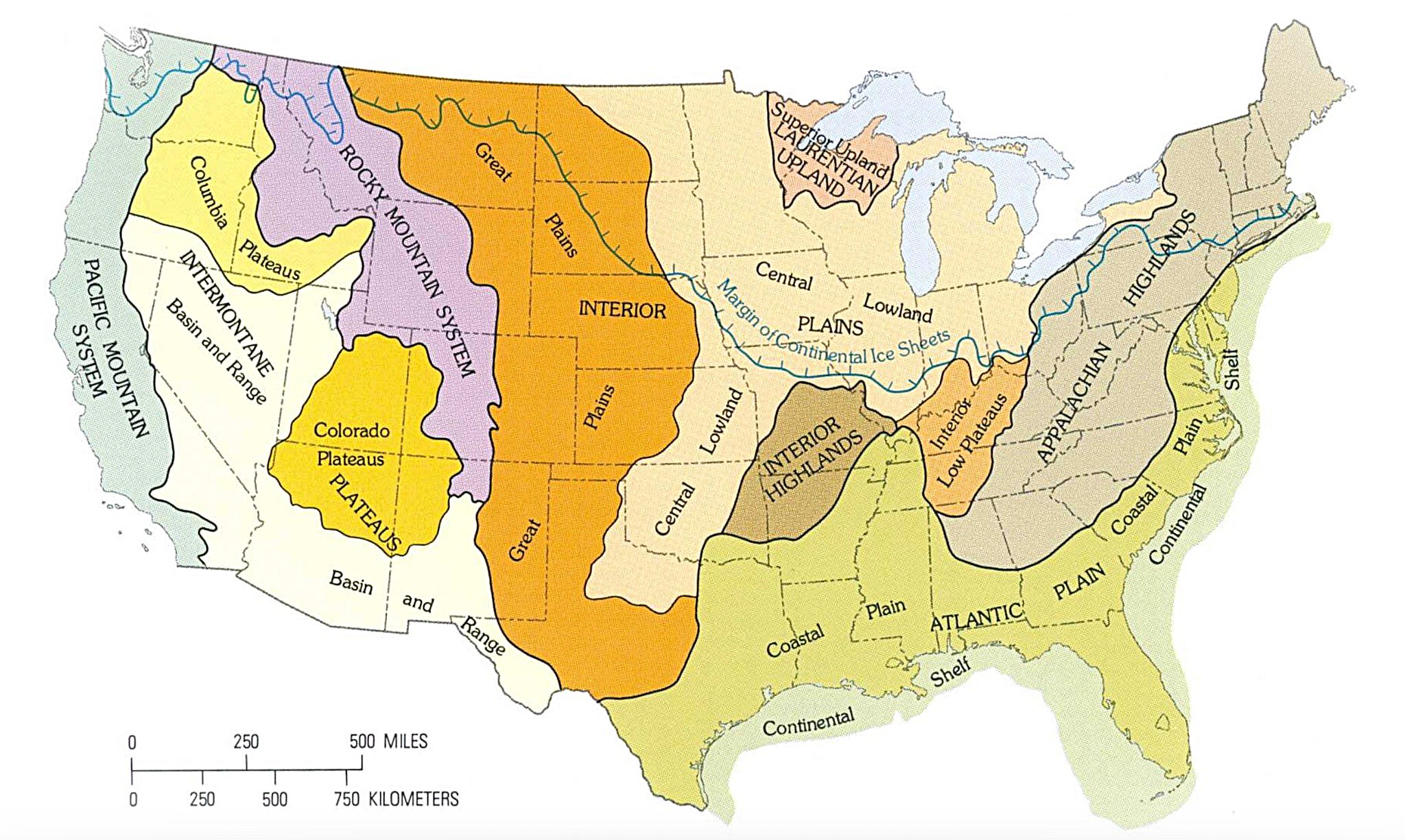
Map by the U.S. Geological Survey
Ever wonder why Kansas feels so different from Colorado, or why the Appalachians have such a distinct personality compared to the Rockies?
The answer lies in a fascinating geological map created by the U.S. Geological Survey that reveals the hidden structure beneath America’s diverse landscape.
The Big Picture: More Than Just Pretty Colors
This isn’t your typical political map with arbitrary state lines. Instead, it shows 25 distinct terrain regions that tell the real story of how our continent was shaped over millions of years.
Each colored zone represents areas with similar geological features, elevation patterns, and landscape characteristics that often ignore state boundaries entirely.
Think of it as nature’s own organizational system. The bright orange Interior Plains stretch from Texas all the way up to the Canadian border, creating America’s agricultural heartland.
Meanwhile, the purple Rocky Mountain System cuts a dramatic swath through the western states, representing some of our youngest and most dramatically uplifted terrain.
Why the West Looks So Different
Notice how the western half of the country resembles a geological patchwork quilt? That’s because this region has been geologically active for much longer, with multiple mountain-building episodes, volcanic activity, and crustal stretching creating complex terrain patterns.
The Colorado Plateaus, painted in cheerful yellow, represent some of the most spectacular scenery in America. This is where you’ll find the Grand Canyon, Zion, and Bryce Canyon.
The region’s relatively flat-lying rock layers, carved by rivers over millions of years, create those iconic stepped cliffs and colorful rock formations that make western national parks so breathtaking.
The East Coast’s Ancient Story
The eastern regions tell a different tale. The Appalachian Highlands, shown in brown tones, represent some of North America’s oldest mountains.
These ancient peaks have been worn down by hundreds of millions of years of erosion, creating the gentle, rounded profiles so different from the sharp peaks of the Rockies.
The Atlantic Coastal Plain, stretching in light green along the eastern seaboard, consists of relatively young sediments that have accumulated as sea levels have risen and fallen over geological time.
This is why much of the East Coast is relatively flat and why cities like Miami sit barely above sea level.
The Geological Democracy of the Great Plains
Perhaps most striking is how the Great Plains and Interior Plains dominate the center of our continent. This vast expanse of relatively flat terrain represents millions of years of sediment deposition, creating some of the world’s most fertile agricultural land. It’s a reminder that sometimes the most important geography is the least dramatic.
Understanding these terrain regions helps explain everything from regional climate patterns to why certain areas are prone to earthquakes, floods, or droughts. It’s the foundation that shapes not just our physical landscape, but our culture, economy, and daily lives.
Next time you’re driving cross-country, remember: you’re not just crossing state lines. You’re traveling through geological time itself.
Help us out by sharing this map: