Map from the British Geological Survey
If you’ve ever wondered why the Scottish Highlands look so dramatically different from the rolling English countryside, or why Wales has such rugged terrain compared to the flat Essex coast, the answer is literally underfoot.
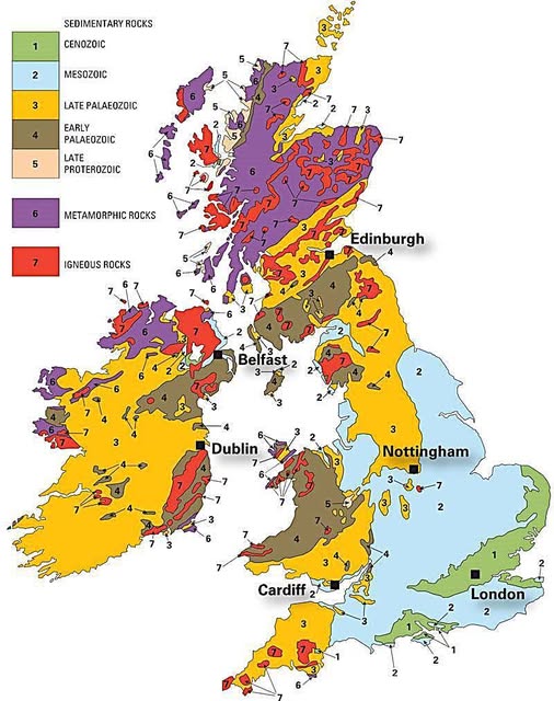
This geological map of Britain and Ireland is one of the most information-dense images you’ll ever stare at, and once you know how to read it, the landscape will never look the same again.
The Old North vs. The Young South
The single most striking pattern on the map is the age divide between north and south.
Scotland and northwest Ireland are dominated by purple (metamorphic rocks) and brown (Early Palaeozoic sedimentary rocks), meaning the ground there is ancient, tough, and heavily compressed by tectonic forces hundreds of millions of years ago. These are some of the oldest rocks in Europe.
Head south toward London and the colours shift to soft green and pale blue, indicating Cenozoic and Mesozoic sedimentary rocks that are geologically speaking, babies.
The famous White Cliffs of Dover and the chalky hills of the southeast formed in the last 65 to 250 million years, largely from marine sediments laid down when warm shallow seas covered the region.
Igneous Intrusions and Volcanic Drama
Those vivid red patches scattered across the map mark igneous rocks, places where molten material either erupted as volcanoes or cooled slowly underground as granite.
The red cluster across northern Scotland, the Scottish islands, and parts of Wales and southwest England tells a story of intense volcanic activity, particularly during the opening of the North Atlantic around 60 million years ago.
Fingal’s Cave and the Giant’s Causeway? Both the result of that dramatic episode.
Ireland’s Colourful Core
Ireland is geologically fascinating because it shows almost the full spectrum of rock types in a relatively compact space.
The west coast features ancient metamorphic and igneous rocks while the interior lowlands are dominated by Carboniferous limestone, the yellow Late Palaeozoic band, which explains why the famous Burren landscape in County Clare looks almost lunar. Thin soils over hard limestone create that haunting, flower-strewn pavement scenery.
Why Any of This Matters
Geology shapes everything from house prices to water quality to farming potential. The fertile plains around Nottingham sit on productive sedimentary geology. The thin acid soils of highland Scotland reflect their hard metamorphic base. Even where your tap water comes from is tied directly to what rock lies beneath your local reservoir.
Next time you’re driving through a motorway cutting and notice layers of rock exposed in the hillside, you’re reading a chapter of a story that started over a billion years ago. Britain and Ireland are, in every sense, built on incredible foundations.
Help us out by sharing this map: