Map by Jacques Bellin (1753)
There is something quietly thrilling about looking at a map made before the world was fully known.
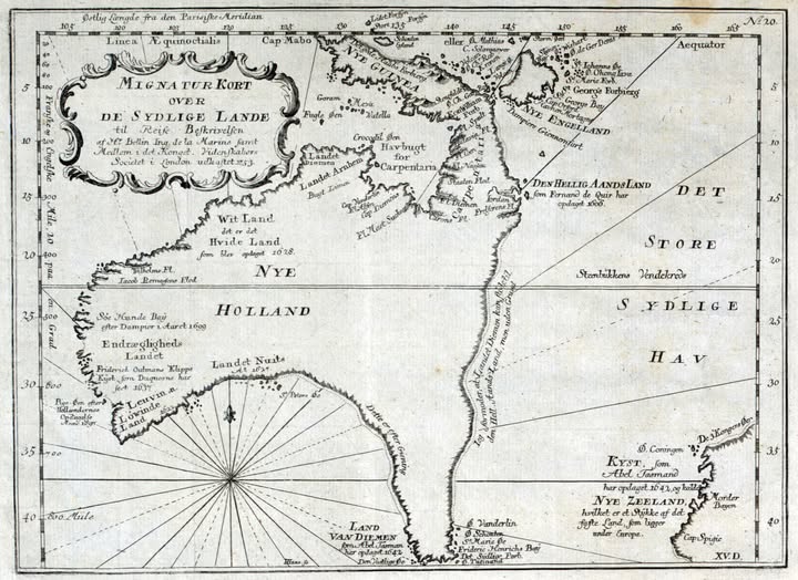
This beautifully engraved map, titled Mignatur Kort over De Sydlige Lande (“Miniature Map of the Southern Lands” in Danish), offers a window into an era when European explorers were still stitching together the edges of the globe.
What Are We Actually Looking At?
The map centres on the vast southern Pacific and Indian Ocean region, and it depicts what we now know as Australia, New Guinea, and New Zealand. But the names here tell a different story entirely.
Australia appears as Nye Holland (New Holland), the name Dutch navigators gave it long before the British arrived. New Guinea sits at the top as Nye Guinea (New Guinea), and tucked into the lower right corner is an early and strikingly incomplete Nye Zeeland (New Zealand), credited to Abel Tasman, whose 1642 voyage is annotated directly on the map.
The Explorers Hiding in Plain Sight
What makes this map genuinely special is how it doubles as a historical ledger. Annotations reference specific voyages and the men who made them.
Fernando de Quir is credited with the discovery of what the map calls Den Hellig Aands Land (Land of the Holy Spirit, modern Vanuatu). William Dampier’s 1699 visit to Sharks Bay is noted. There are references to the coastline being charted as recently as 1628 in places.
The western coast of Australia is labelled Wit Land and Hvide Land (White Land), reflecting just how partial and piecemeal early coastal surveys were.
Why It Matters Beyond the Aesthetics
Maps like this one were working documents. Published for navigators, geographers, and the curious educated public, they represented the absolute frontier of human knowledge. The blank and speculative sections were not artistic choices; they were honest admissions of ignorance.
The Det Store Sydlige Hav (the Great Southern Ocean) stretches across the right half of the map, enormous and largely empty, a reminder that for all the annotations and careful engravings, most of the ocean remained uncharted and deeply dangerous.
A Beautiful Artifact of an Age of Curiosity
Likely produced in Denmark or the Netherlands in the early to mid-1700s, this map sits at the intersection of art, science, and adventure. For anyone interested in the history of exploration, cartography, or the shaping of the modern world, it is a remarkable object. Every annotation is a human story. Every blank space is a question not yet answered.
Sometimes the most honest maps are the ones with the most missing.
Help us out by sharing this map: