Map from Encyclopedia Britannica
Every year, with remarkable consistency, a wall of warm, moisture-laden air begins creeping northward from the Indian Ocean. It follows almost the same invisible calendar it has followed for thousands of years.
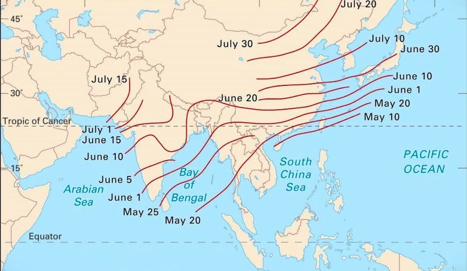
Scientists can map its arrival dates to within a few days across an entire continent. That map is what you’re looking at above, and it tells a fascinating story.
Reading the Lines
Those red curves aren’t contour lines showing elevation. They are isochrones, lines connecting places where the monsoon arrives on the same date. Think of them as a weather front’s diary entries, each one marking where the rain showed up and when.
The journey begins around May 20 near the southern tip of India and over the open waters south of the Bay of Bengal. From there, the monsoon pushes steadily northward and eastward over the following weeks.
A Month Across India
By June 1, the rains have soaked the southwestern coast of India and the tip of the Indochina peninsula. Just two weeks later, by June 15, the monsoon has climbed deep into central India. The whole subcontinent is typically blanketed by July 1, which is why Indian farmers have planned their planting cycles around this calendar for millennia.
Notice how the lines bunch together over India compared to how they fan out over East Asia. That bunching means the monsoon sweeps across India relatively quickly, while its advance slows and spreads more gradually over China and Japan.
Two Branches, One System
The monsoon actually splits into two arms as it moves north.
One branch drives moisture up through the Bay of Bengal into northeastern India and Bangladesh (one of the wettest regions on Earth). The other travels up through the Arabian Sea toward western India and Pakistan.
Japan Gets Its Turn Last
By late June and into July, the monsoon influence reaches southern Japan and Korea, eventually arriving in northern China around July 20 to July 30.
For Japan, this rainy season has its own name: tsuyu, meaning “plum rain,” named after the season when plums ripen.
Why This Actually Matters
Half of humanity lives in the regions covered by this map, and their water supply, food production, and economies are tied directly to whether those lines arrive on schedule. A monsoon that comes late or weak can mean drought. One that arrives too early or intensely can trigger devastating floods.
This map is, in a very real sense, a map of when billions of people can exhale with relief each year, knowing the rains have come.
Help us out by sharing this map: