Map found on Reddit
You’ve seen maps of China. You probably think you have a decent sense of how big it is. This image is here to respectfully prove you wrong.
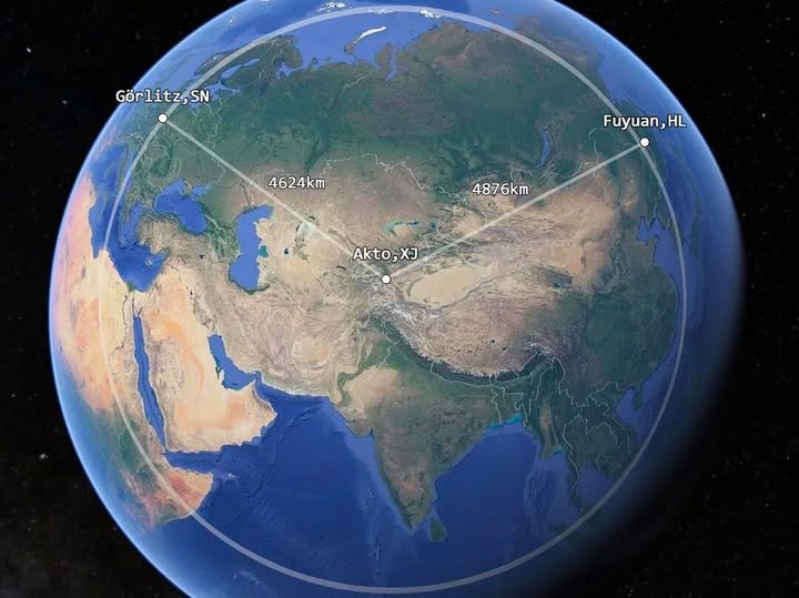
The screenshot above, taken from Google Earth, plots three locations with two connecting lines, and the numbers attached to those lines are genuinely startling once you understand what you’re looking at.
What Are These Three Places?
Let’s break down the dots on the map.
Görlitz, SN sits on the far eastern edge of Germany, right on the Polish border. It is the easternmost city in Germany, a charming and somewhat obscure town in Saxony.
Akto, XJ is a county in Xinjiang, China’s enormous western autonomous region. It sits near the western extremity of Chinese territory, deep in Central Asia.
Fuyuan, HL is in Heilongjiang province, tucked into China’s northeastern corner, and is widely regarded as the easternmost point of mainland China.
The Numbers That Stop You in Your Tracks
The map draws a line from Görlitz to Akto: 4,624 km.
Then it draws a second line from Akto to Fuyuan: 4,876 km.
Read that again. The distance from Germany’s eastern border all the way across Central Asia to the western edge of China is slightly shorter than the width of China itself.
To put it another way: if you drove from the eastern tip of Germany to China’s western doorstep, you would still have a longer journey ahead of you just to cross China from west to east.
Why Does This Matter?
China spans five geographic time zones, though it operates on a single official one (Beijing Time), meaning sunrise in Xinjiang can occur three hours later than in Shanghai by solar reckoning.
The country covers roughly 9.6 million square kilometres, making it the third or fourth largest nation on Earth, depending on how you measure disputed territories.
Most Western mental maps drastically compress Asia. We see it on a flat projection and assume the proportions are roughly familiar. They are not.
The Takeaway
Geography is one of those subjects that rewards a second look. A single well-constructed map, like this one, can recalibrate your intuition in seconds. The next time someone describes China as a “regional” power, picture this globe, those two lines, and the fact that crossing the country from west to east covers more ground than travelling from Berlin to the border of China itself.
That is not a regional scale. That is a continental one.
Help us out by sharing this map: