Map by Malcom Kenton / National Association of Railroad Passengers
Remember when you could hop on a train from almost anywhere and get to almost anywhere else in America?
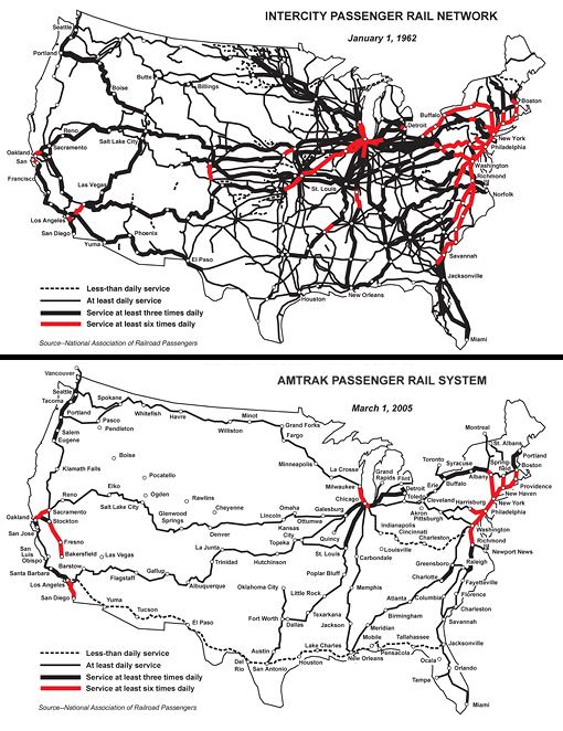
These fascinating maps tell a story that might surprise you: in just 43 years, the United States went from having one of the world’s most comprehensive passenger rail networks to… well, whatever we have now.
The Golden Age of Rail Travel
In 1962, America’s intercity passenger rail network was truly something to behold. Dense spider webs of black lines crisscrossed the continent, connecting major cities and small towns alike.
You could catch a train from Seattle to Miami, from Boston to San Francisco, or take countless routes that simply don’t exist today. This was the tail end of the golden age of American rail travel, when trains were still a primary mode of long-distance transportation.
The network was so comprehensive that even smaller cities had multiple daily departures. Routes radiated out from major hubs like Chicago, which truly lived up to its reputation as the railroad capital of America.
The Northeast Corridor was already busy, but so were lines through the heartland, across the Great Plains, and along the Pacific Coast.
Enter Amtrak and the Great Shrinkage
By 2005, the picture had changed dramatically.
The creation of Amtrak in 1971 was supposed to save passenger rail service, but what it really did was consolidate the remaining viable routes while abandoning hundreds of others.
The comparison is stark: where once there were thick networks of lines, now there are mostly single threads connecting major population centers.
The red lines on the 2005 map tell the story of what survived: primarily the Northeast Corridor, a few cross-country routes, some California connections, and scattered regional services.
Entire states that once had multiple passenger rail options were left with little or no service at all.
What Happened to All Those Trains?
The decline wasn’t sudden; it was death by a thousand cuts. Airlines became faster and more affordable, the Interstate Highway System made car travel more convenient, and railroad companies found freight more profitable than passengers.
Government subsidies flowed to highways and airports while passenger rail was left to fend for itself in the marketplace.
Cities that once boasted grand union stations saw them demolished or converted to shopping centers. Rail lines were abandoned or converted to freight-only operation.
A transportation option that had connected communities for over a century simply faded away.
The Cost of Our Car-Centric Choice
Today, as we grapple with traffic congestion, environmental concerns, and the true costs of car dependency, these maps serve as a reminder of what we gave up. While Europe and Asia invested in high-speed rail and maintained comprehensive networks, America doubled down on individual automobile transportation.
The irony is that many of the routes shown in 1962 would be incredibly useful today. Imagine being able to take a train from Nashville to Atlanta, or from Phoenix to San Antonio, or from Minneapolis to Kansas City. These connections existed once, serving communities that today have few transportation alternatives beyond driving or flying.
Looking at these maps, you can’t help but wonder: what if we had made different choices?
Help us out by sharing this map: