Map by the Charles River Watershed Association
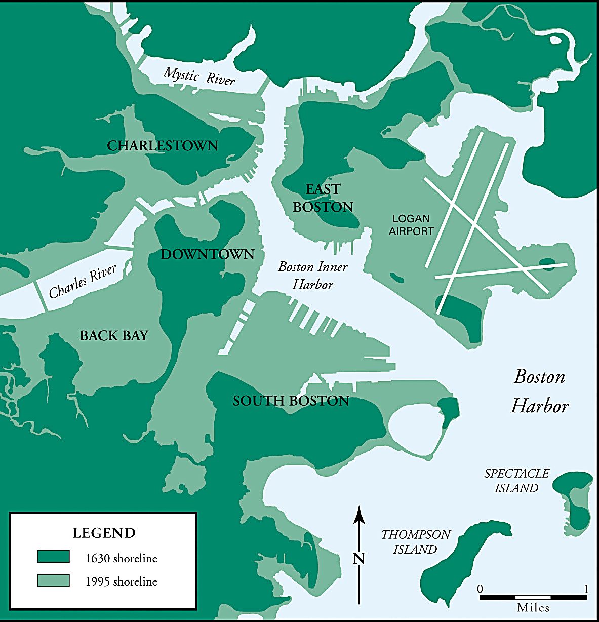
Looking at modern Boston, you’d never guess that nearly half the city used to be underwater. But that map tells an incredible story: over 365 years, Bostonians literally moved mountains and filled harbors to triple their city’s size.
What started as a small peninsula became the sprawling metropolis we know today, all through one of history’s most ambitious urban makeovers.
The Great Boston Land Grab Begins
Back in 1630, Boston was basically a glorified island connected to the mainland by a narrow strip of land called Boston Neck.
The original settlers found themselves cramped on the Shawmut Peninsula, surrounded by water on three sides. Rather than accept their watery fate, they did what any determined New Englanders would do: they decided to fight the ocean and win.
The early colonists started small, filling in marshes and coves around the original settlement. But as Boston grew into a major port city, the demand for buildable land became desperate. By the 1800s, city planners were eyeing every inlet, bay, and tidal flat as potential real estate.
Engineering Meets Ambition in Back Bay
The most famous transformation happened in the Back Bay area during the mid-1800s. What was once a smelly tidal marsh became some of Boston’s most elegant neighborhoods.
Engineers used an ingenious system of railroad cars to haul millions of tons of sand and gravel from nearby hills. They worked around the clock for decades, creating the grid of Victorian brownstones that still defines the area today.
The project was so massive that it required flattening entire hills around Boston. Beacon Hill lost about 60 feet of elevation, and other hills simply disappeared entirely. One person’s mountain became another person’s foundation.
From Harbor to Neighborhoods
The transformation wasn’t limited to Back Bay. Look at the map and you’ll see how Boston Inner Harbor shrank dramatically.
Areas like East Boston and South Boston expanded far beyond their original boundaries. Logan Airport sits on land that was completely underwater in 1630, built on filled tidelands and artificial islands.
Even the Charles River got a makeover. The meandering waterway was straightened and narrowed, with its former oxbows and marshes becoming solid ground for development. The Mystic River saw similar changes, with entire neighborhoods rising from what used to be a riverbed.
A City Built on Borrowed Land
Today’s Boston stands as a testament to human determination and engineering prowess. Nearly 5,500 acres of the modern city exist only because earlier generations refused to accept natural boundaries. From Fenway Park to the Financial District, much of what makes Boston iconic sits on land that fish once called home.
The next time you walk through downtown Boston, remember: you’re literally walking on water.
Help us out by sharing this map: