Map found on Reddit (originally by u/skan76)
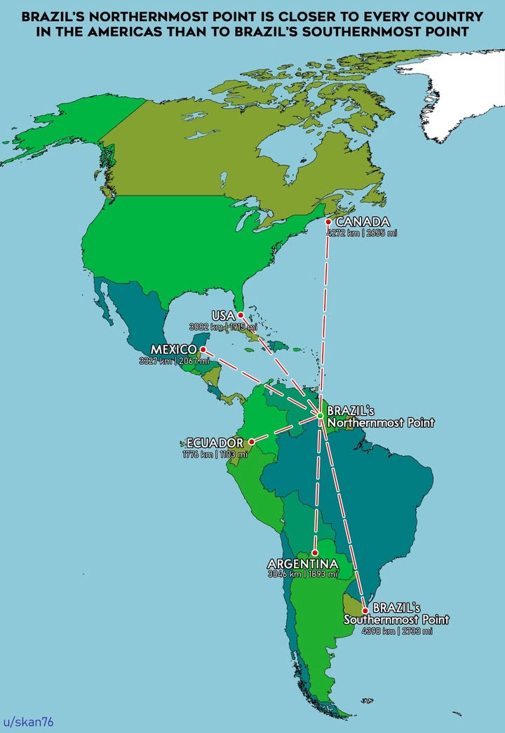
When you think about Brazil, you probably picture beaches in Rio, the Amazon rainforest, or maybe that massive statue of Christ the Redeemer. But here’s a geographic fact that will make you do a double-take: Brazil’s northernmost point is literally closer to every single country in the Americas than it is to Brazil’s own southernmost point.
Let that sink in for a moment. This South American giant is so enormous that its northern border has more in common, distance-wise, with Canada than with its southern regions.
Breaking Down the Numbers
The map reveals some truly staggering distances. From Brazil’s northernmost point, Canada sits at 5,525 kilometers away, while the USA is just 5,062 kilometers distant. Mexico? A mere 3,847 kilometers. Even Ecuador, tucked away on the Pacific coast, is only 1,778 kilometers from Brazil’s northern border.
But here’s where it gets wild: Brazil’s own southernmost point is a whopping 4,394 kilometers away from its northern tip. That means you could travel from northern Brazil to multiple other countries and still not cover the distance needed to reach southern Brazil.
Why This Matters More Than You Think
This isn’t just a fun party trick for geography nerds. Brazil’s immense size has real implications for everything from trade routes to cultural diversity. Think about it: northern Brazilians living near the Venezuelan border have more in common geographically with Caribbean nations than with their fellow citizens in the southern states.
The country spans multiple climate zones, from tropical rainforests in the north to temperate regions in the south. It’s like having several different countries rolled into one massive nation.
Putting Brazil’s Size in Perspective
To truly appreciate these numbers, consider that Brazil covers 8.5 million square kilometers, making it the fifth-largest country in the world. It’s larger than the entire continental United States and takes up nearly half of South America’s total landmass.
When early Portuguese explorers first mapped this territory, they probably had no idea they were claiming a chunk of land so vast that its extremes would be closer to foreign nations than to each other.
This geographic quirk perfectly illustrates why Brazil is considered a continent-sized country. The next time someone mentions Brazil, remember that this single nation stretches across distances that would make most European countries seem like city-states in comparison.
Help us out by sharing this map: