Map by Reddit user denn23rus
When you think of Europe, what comes to mind? Perhaps the romantic canals of Venice, the bustling streets of London, or the historic boulevards of Paris.
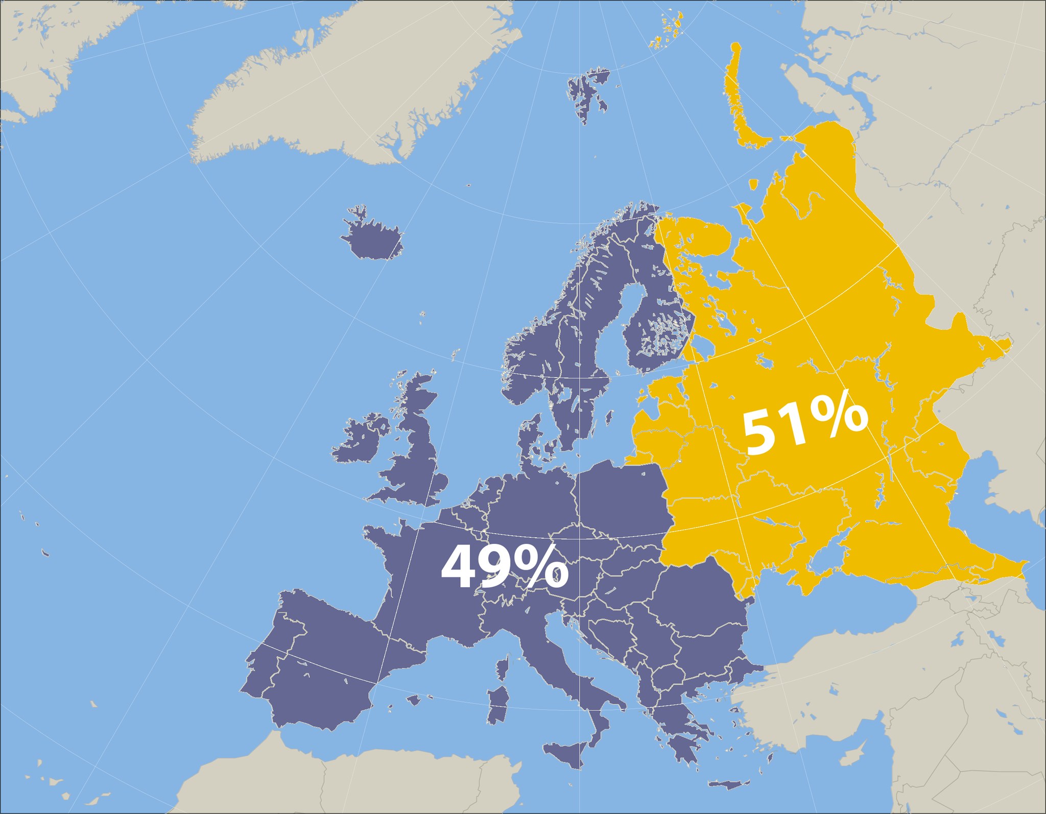
But here’s a geographical reality that might surprise you: the countries that once formed part of the Soviet Union actually control more than half of Europe’s total land area.
The Numbers Tell a Striking Story
Looking at the map, the division is remarkably clear. Former Soviet states, highlighted in yellow, account for 51% of Europe’s landmass, while all other European countries combined make up just 49%.
This isn’t just a statistical curiosity; it reveals how dramatically the collapse of the USSR reshaped our understanding of European geography.
Russia: The Continental Giant
The primary driver behind this statistic is Russia itself. Even when considering only its European territory (west of the Ural Mountains), Russia dwarfs every other European nation. Its European portion alone spans roughly 4 million square kilometers, making it larger than the entire European Union combined.
But Russia isn’t the only player in this geographic equation. Countries like Ukraine, Belarus, and the Baltic states add substantial territory to the former Soviet tally.
Ukraine, Europe’s second-largest country by area, contributes over 600,000 square kilometers to this total.
Why This Matters Today
This geographic reality has profound implications for understanding modern European politics and economics.
The sheer scale of former Soviet territory means these nations control vast natural resources, from Russian oil and gas reserves to Ukrainian agricultural lands that feed much of the world.
The map also helps explain why European energy security has become such a critical issue. When a single political entity once controlled more than half the continent’s landmass, the economic and strategic relationships that developed during that period continue to influence European affairs decades later.
Beyond the Borders
What makes this even more fascinating is how it challenges our mental maps of Europe.
Western European nations, despite their economic and political influence, occupy a surprisingly small portion of the continent’s actual territory. Countries like Germany, France, and the United Kingdom, while densely populated and economically powerful, are geographically modest compared to their eastern neighbors.
This geographic distribution also explains why European integration remains complex. The European Union, despite its 27 member states, actually governs less than half of Europe’s landmass. Any truly continental European project must grapple with this fundamental geographic reality.
The Takeaway
Geography shapes politics, economics, and culture in ways we don’t always recognize. The next time you look at a map of Europe, remember that the former Soviet states aren’t just another collection of countries; they’re literally the majority of the continent. Understanding this helps explain everything from energy politics to agricultural trade, and why European history continues to be written across this vast eastern expanse.
Sometimes the most important truths are hiding in plain sight on the map.
Help us out by sharing this map: