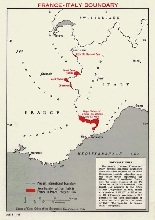
Map created by the U.S. Department of State (Public Domain)
Most people know World War II ended in 1945, but the political reshaping of Europe quietly continued for years afterward.
This fascinating map, produced by the U.S. Office of the Geographer, tells one of those overlooked stories: the moment France gained a handful of strategic Alpine territories from Italy under the Paris Peace Treaty of 1947.
What the Red Areas Actually Mean
Those bold red patches aren’t just decorative. Each one marks a specific area officially transferred from Italian to French sovereignty.
The key zones include the Mont Cenis Plateau, the area around Mont Thabor and Chaberton, the Little St. Bernard Pass near Mont Blanc, and arguably the most significant cluster: the Upper Valleys of La Tinée, La Vésubie, and La Roya, tucked just behind Nice in the Maritime Alps.
These weren’t random grabs. France had strategic, geographic, and in some cases ethnic justifications for each claim, and the Allied powers backed them as part of Italy’s postwar settlement following its role as an Axis power.
The Geography Makes It Make Sense
Notice how the boundary roughly follows the water divide separating the Rhône basin of southeast France from the upper reaches of the Po Valley in the Italian Piedmont. That’s not an accident.
Natural watersheds have historically been considered logical, defensible borders, and the treaty largely formalized what geography had been quietly suggesting for centuries.
The total boundary runs approximately 488 kilometers (around 303 miles), with France holding about 17.6 percent of the shared land boundary and Italy the remaining 25.3 percent. The transferred territories represented a meaningful, if modest, westward nudge of the border.
Why This Still Matters
The Roya Valley transfer, in particular, has lingered in cultural memory. The valley’s residents had actually voted to join France in an 1860 plebiscite, but were kept in Italian hands due to diplomatic maneuvering. The 1947 treaty finally resolved that long-standing tension, almost a century later.
Today, these areas are thoroughly French in administration, though the Alpine communities retain distinct local identities shaped by centuries of cross-border life.
The Bigger Takeaway
Maps like this are a reminder that borders are never truly permanent. They reflect the power dynamics, negotiations, and compromises of their era. The France-Italy boundary we see on Google Maps today is not the one that existed in 1946, and understanding why makes the landscape feel surprisingly alive with history.
Next time you drive through the Maritime Alps or ski near Mont Cenis, you are quite literally crossing ground that changed hands within living memory.
Help us out by sharing this map: