Map by Heraldry / Wikimedia Commons
Ever looked at a map and wondered what North America might have looked like with different borders? Well, for a brief but fascinating moment in history, Mexico stretched from ocean to ocean and nearly to the Canadian border.
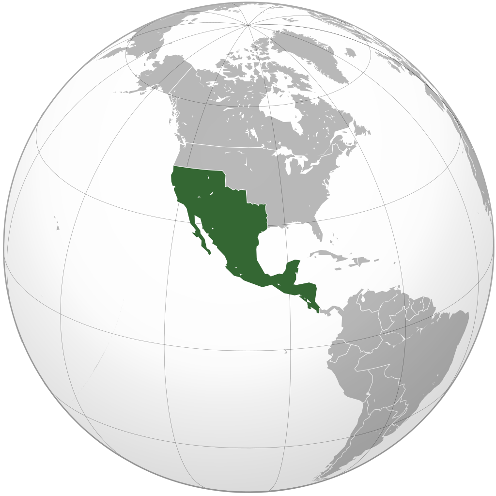
In 1823, the Mexican Empire reached its absolute territorial peak, encompassing an area that would make modern geographers do a double-take.
From Independence to Empire
Fresh off winning independence from Spain in 1821, Mexico found itself inheriting vast territories that Spanish colonizers had claimed over three centuries.
Under Emperor Agustín de Iturbide, the newly formed Mexican Empire controlled not just present-day Mexico, but also large chunks of what we now call the American Southwest, plus most of Central America.
The empire included modern-day California, Nevada, Utah, Arizona, New Mexico, Texas, and parts of Colorado, Wyoming, Kansas, and Oklahoma. But it didn’t stop there.
The Mexican Empire also stretched south to include Guatemala, Belize, El Salvador, Honduras, Nicaragua, and Costa Rica. Talk about ambitious borders.
A Giant That Couldn’t Hold Together
Here’s the thing about massive empires built on colonial foundations: they’re incredibly difficult to govern effectively. The Mexican Empire faced the same challenges that had plagued Spain for centuries.
Communication across such vast distances was nearly impossible with 1820s technology. Different regions had distinct cultures, economies, and priorities that often conflicted with central authority.
The empire was also dealing with serious financial troubles inherited from the independence wars. Managing territories that spanned from tropical rainforests to desert landscapes, each with unique needs and resources, proved overwhelming for the young nation.
The Great Shrinking Act
By 1823, cracks were already showing. Central American provinces began declaring independence, forming what would become the Federal Republic of Central America. The empire that had seemed so promising just two years earlier was rapidly fragmenting.
Emperor Iturbide was forced to abdicate in March 1823, and Mexico transitioned to a republic. But the territorial losses were just beginning.
Over the following decades, Mexico would lose even more territory through various conflicts and treaties, including the famous Texas Revolution and the Mexican-American War.
Why This Matters Today
Understanding the Mexican Empire’s peak helps explain many modern political and cultural dynamics in North America. The influence of Mexican law, culture, and settlement patterns can still be seen throughout the American Southwest. Cities like Los Angeles, San Francisco, and Santa Fe all have deep Mexican roots that predate American control.
The brief existence of this massive empire also reminds us how dramatically borders can change in relatively short periods. What seemed permanent and natural to people in 1823 would be completely transformed within a generation.
Next time you’re looking at a map of North America, imagine those green borders stretching much further north and south. For one shining moment, Mexico truly was a continental power.
Help us out by sharing this map: