Map by Reddit user MaxKorting
Ever wondered what the Netherlands looked like before it became the compact, densely populated country we know today? The transformation is nothing short of extraordinary.
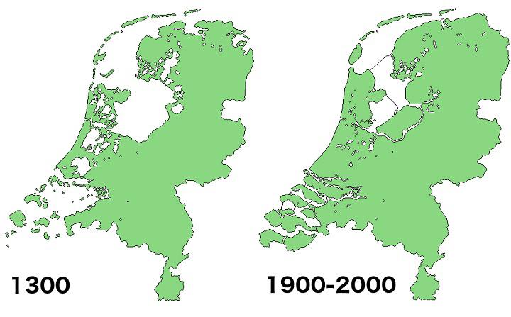
In 1300, much of what we now call the Netherlands was actually underwater or consisted of scattered islands and marshlands.
A Nation Built on Water Management
The medieval Netherlands was a vastly different place. Large portions of the country were submerged beneath the Zuiderzee (Southern Sea), and countless rivers, lakes, and wetlands dominated the landscape.
What existed was a fragmented collection of higher ground areas, islands, and coastal settlements that had learned to live with, rather than against, the water.
The Dutch didn’t just accept their watery fate. They became masters of hydraulic engineering, developing sophisticated techniques to drain land and keep the sea at bay.
This wasn’t just about survival; it was about creating new opportunities for agriculture, trade, and settlement.
The Great Land Grab From Mother Nature
Over the centuries, the Dutch systematically reclaimed land through an ingenious system of polders. These are low-lying areas enclosed by dikes, with water pumped out to create dry, fertile land. Initially powered by windmills, and later by steam and electric pumps, this process transformed the country’s geography entirely.
The most dramatic change came with the creation of the IJsselmeer and the reclamation of the Zuiderzee. What was once a massive inland sea became a freshwater lake surrounded by new provinces like Flevoland, which didn’t even exist in 1300.
More Than Just Engineering
This transformation represents more than impressive engineering. It reflects the Dutch spirit of innovation, persistence, and working collectively toward ambitious goals.
The famous saying “God created the world, but the Dutch created the Netherlands” isn’t just a clever quip; it captures centuries of human determination to reshape an entire nation.
The reclaimed areas became some of the most fertile agricultural land in Europe, supporting the Netherlands’ reputation as a major food exporter despite its small size. These new lands also provided space for cities, ports, and the infrastructure that would make the Netherlands a global trading powerhouse.
A Living Testament to Human Ingenuity
Today’s Netherlands stands as proof that geography isn’t destiny. Through seven centuries of careful planning, innovative engineering, and sheer determination, the Dutch literally created land where none existed before. The next time you see a map of the Netherlands, remember that much of what you’re looking at was once beneath the waves.
This remarkable transformation continues today, with new projects and technologies ensuring that the Netherlands remains both below sea level and above water, a testament to what humans can achieve when they refuse to accept limitations.
Help us out by sharing this map: