Map reproduced by East of Nowhere
There is something deeply satisfying about a beautifully crafted historical map, and this county map of the State of New York is one of the finest examples you will ever come across.
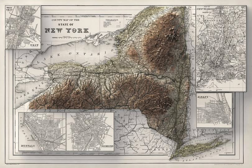
With its rich topographic shading, elegant typography, and inset city plans tucked into the corners, it tells the story of a state that was actively figuring out what it wanted to be.
Relief Shading Before Computers Existed
The most striking feature of this map is the dramatic terrain rendering across the central and eastern portions of the state. The Adirondack Mountains and the Catskills rise off the page in warm brown tones, achieved entirely through hand engraving.
Cartographers of this era used a technique called hachuring combined with stippling to suggest elevation and shadow, long before digital elevation models or satellite imagery existed. The result is almost painting-like, and frankly puts a lot of modern maps to shame.
The Cities Get Their Own Stage
Notice how the mapmaker dedicated four separate inset panels to the major urban centers of the day: Buffalo, Rochester, Troy with West Troy, and Albany each get their own detailed street grid. New York City and its vicinity occupy a generous panel in the upper right corner, already showing the complexity of a metropolis in full stride.
This was standard practice for important county maps of the 19th century. Subscribers expected both the big picture and the fine detail, and the best cartographic publishers delivered both on a single sheet.
Lake Ontario and the Erie Corridor
The western portion of the map reveals just how central the Great Lakes were to New York’s early economy. Lake Ontario dominates the northern edge while Lake Erie frames the southwest corner near Buffalo.
The Erie Canal, which had transformed the state into a commercial powerhouse decades earlier, is visible threading eastward through the lowland corridor between the lakes and the Adirondacks. This single waterway essentially built modern New York by connecting the Hudson River to the interior of the continent.
Why Maps Like This Still Matter
Beyond their obvious aesthetic appeal, maps like this one are primary historical documents. County boundaries shift, city names change, and transportation routes evolve. A map frozen in time captures the political and economic priorities of its moment with a precision that written records often cannot match.
Whether you are a history enthusiast, a New York native, or simply someone who appreciates extraordinary craftsmanship, this map rewards close attention. Zoom in on any corner, and you will find something new: a township name, a rail line, a carefully rendered river bend.
They do not make them like this anymore, and that is exactly what makes them worth celebrating.
Help us out by sharing this map: