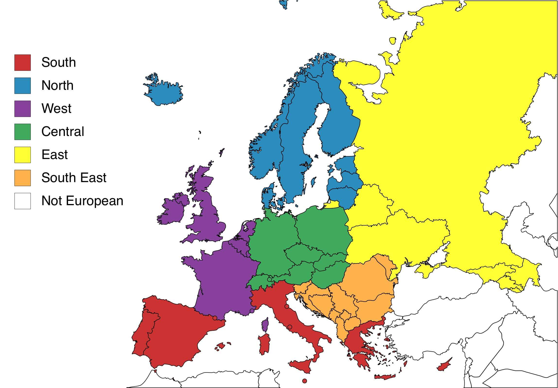
The map above shows the geographical regions of Europe. This map is known as a geopolitical map. It shows the legal borders set by every country.
First, the northern European region, marked in blue. Eight countries comprise this region. These include:
- Iceland
- Norway
- Sweden
- Finland
- Estonia
- Latvia
- Lithuania
- Denmark
Denmark has a territory named Greenland. It is a large, icy landmass located northeast of Canada in North America. Since Greenland is part of Denmark, it is considered to be European as well.
The eastern region is marked by the color yellow. It consists of six countries:
- Russia
- Georgia
- Armenia
- Azerbaijan
- Belarus
- Ukraine
Do you see that small yellow piece of land in the southwest of Lithuania (marked in blue)? This is the Kaliningrad territory, which is owned by Russia. It is therefore part of the continent’s eastern region.
Eleven countries, meanwhile, comprise the southeast region of Europe. This region is indicated on the map by the color orange. These countries are:
- Slovenia
- Croatia
- Bosnia and Herzegovina
- Montenegro
- Kosovo
- Albania
- Macedonia
- Bulgaria
- Romania
- Moldova
With eleven countries, Europe’s southeast region comprises the most countries out of all the continent’s regions.
Eight countries and one city-state, marked in red, are from Europe’s southern region. These are:
- Portugal
- Spain
- Andorra
- Italy
- Vatican City
- San Marino
- Malta
- Greece
- Cyprus
Two red dots are inside the landmass of Italy. The one in the northeast is the small country of San Marino. The dot in central Italy is the city-state of Vatican City, which houses the Holy See, the headquarters of the Roman Catholic Church.
There is another dot in the south of Italy, and that is the island country of Malta.
Italy also includes the Sardinia island located in the Mediterranean Sea, west of the country’s mainland.
Spain also has the Balearic islands located east of its mainland. A small dot is also seen in the extreme northeastern part of Spain – that’s the country of Andorra.
The island country of Cyprus is located south of Turkey, which is considered to be a Eurasian country – a part of both Europe and Asia.
Seven countries, which are shown in violet, are from the western European region:
- Ireland
- United Kingdom
- France
- Monaco
- Luxembourg
- Belgium
- The Netherlands
The small dot in the southeast of France is the small country of Monaco. Speaking of France, the country also includes the Corsica island in the Mediterranean Sea, in the southeast of the mainland.
Lastly, the central European region, marked in green, hosts eight countries, and these include:
- Germany
- Poland
- Czech Republic
- Slovakia
- Hungary
- Austria
- Switzerland
- Liechtenstein
In the border between Switzerland (west) and Austria (east), there is a small green dot – it is where the country of Liechtenstein is located.
Help us out by sharing this map:
I could not refrain from commenting. Perfectly written!
Hey there! Would you mind if I share your blog with my
myspace group? There’s a lot of people that I think would really
appreciate your content. Please let me know. Thanks
hey there and thank you for your info – I have definitely picked up anything new from right here.
I did however expertise a few technical points using this site, since I experienced to
reload the website lots of times previous to I could get it to
load properly. I had been wondering if your hosting is OK?
Not that I am complaining, but sluggish loading instances times will very frequently affect your placement in google and can damage your high quality score if advertising and marketing with Adwords.
Well I’m adding this RSS to my email and can look out for a
lot more of your respective intriguing content. Make sure
you update this again very soon.
This paragraph will assist the internet users for creating new web site or even a weblog from start to end.
Outstanding story there. What happened after? Take care!
Right away I am going to do my breakfast, later than having my breakfast coming yet again to
read additional news.