Map by Reddit user RedGolpe
We’ve all grown up staring at wall maps in classrooms, and most of us have developed what we think is a pretty solid mental picture of where things are. North America sits above South America, right? They’re stacked like pancakes, with one directly on top of the other.
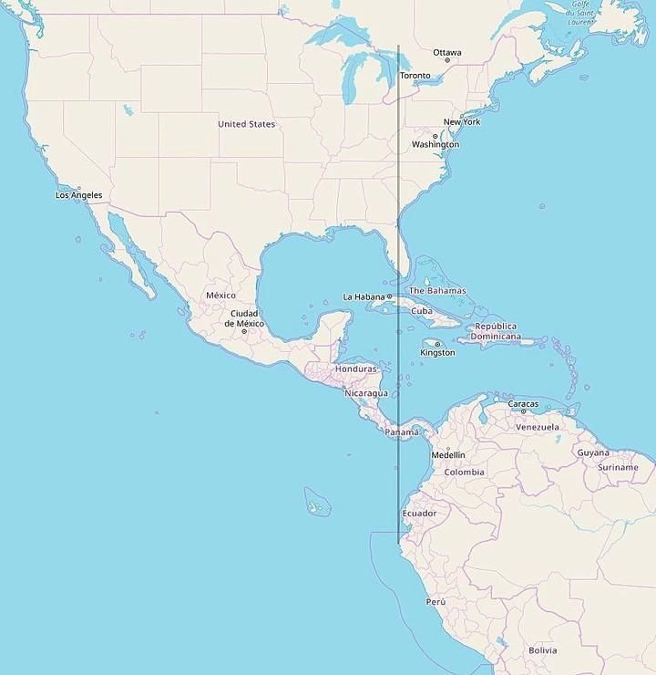
Except here’s the thing: if you actually look at the coordinates, the entire continental landmass of South America is located east of Michigan.
Yes, you read that right. Every single square inch of the South American continent sits to the east of Detroit, Grand Rapids, and even the Upper Peninsula.
Why This Breaks Our Brains
This fact sounds impossible at first because we’re so used to seeing the Americas on maps with South America appearing “below” North America. Our brains automatically interpret “below” as “directly south,” but geography doesn’t work that way.
South America actually swoops dramatically to the east, with most of the continent occupying longitudes that would surprise anyone who hasn’t looked closely at a globe lately.
If you drew a straight line due south from Michigan, you’d hit the Pacific Ocean somewhere west of Chile and Peru. To actually reach the South American mainland, you’d need to travel southeast from Michigan.
The Numbers Don’t Lie
Michigan’s western border sits at approximately 90 degrees west longitude.
Meanwhile, the westernmost point of mainland South America, which is in Peru, clocks in at about 81 degrees west. That means even the farthest western edge of South America is still about 9 degrees of longitude east of Michigan’s western boundary.
To put this in perspective, Quito, Ecuador sits almost directly south of Miami. Buenos Aires, Argentina is roughly on the same longitude as New York City. The continent is much more Atlantic-facing than many people realize.
What This Teaches Us About Perspective
This geographic quirk reminds us that our mental maps are often shaped more by the conventions of mapmaking than by actual spatial relationships. The Mercator projection and other common map styles can distort our perception of where things really are relative to each other.
It’s also a great reminder to occasionally zoom out and look at our planet from different angles. A quick spin of a globe reveals relationships that flat maps obscure. South America’s eastward position becomes immediately obvious when you’re looking at a sphere instead of a rectangle.
Next time you’re planning a trip or just daydreaming about distant places, remember: geography is full of surprises, and sometimes the most basic assumptions we make about our world turn out to be wonderfully wrong.
Help us out by sharing this map: