Map by Urbano Monte (1587)
Most old maps are curiosities. This one is a jaw-drop.
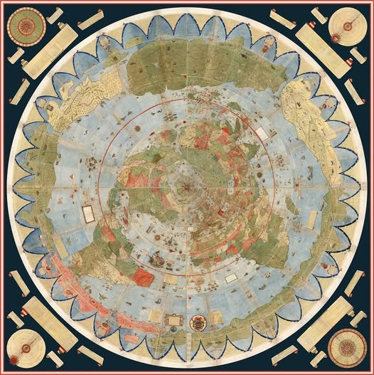
What you are looking at is the Urbano Monte world map, completed in 1587 by a Milanese cartographer who apparently decided that making a normal map was far too boring. Monte produced 60 individual sheets that, assembled together, create one of the largest hand-drawn maps in history, stretching roughly 10 feet across.
And yes, he centered it on the North Pole. On purpose.
Why Does It Look So Strange?
The circular, polar azimuthal projection throws most modern viewers off immediately. We are so conditioned to the Mercator projection (the flat rectangle that hangs in every classroom) that seeing the world viewed from directly above the North Pole feels almost dreamlike.
Antarctica wraps around the entire outer edge. Europe, Asia, and the Americas fan out from the center like petals on a flower.
It is disorienting because it is honest. This projection actually preserves directional accuracy from the center point better than Mercator does, which wildly distorts landmasses near the poles (hello, comically enormous Greenland).
What Monte Got Right… and Wonderfully Wrong
For 1587, the geographic accuracy is genuinely impressive. Europe and the Mediterranean are rendered with real confidence. Japan appears. The coastlines of North and South America, still being actively explored at the time, are recognizable if imperfect.
Then things get delightfully strange. A massive, phantom continent hugs the southern edge, a speculative “Terra Australis” that cartographers invented because they assumed a large landmass must exist in the south to “balance” the world.
California is drawn as a peninsula. Mythical sea creatures patrol the oceans. The further from Europe, the more imagination fills in the gaps.
The Detail Is Staggering
Scroll in mentally, and you find cities, mountain ranges, trade routes, notes in Italian, decorative compass roses, and illustrations of local peoples and animals. Monte was not just making a navigational tool. He was making a statement: here is everything we know about the world, assembled in one extraordinary object.
It sat largely unappreciated for centuries until Stanford University digitally assembled the 60 sheets in 2017, finally letting the world see it as Monte intended.
Why It Still Matters
This map is a perfect snapshot of a civilization in the middle of discovering itself. Confident where knowledge existed, wildly speculative where it did not, and breathtakingly ambitious throughout. In an era of Google Maps and satellite imagery, there is something deeply moving about a man in Milan, armed with ink and ambition, trying to draw the entire world from scratch.
He nearly pulled it off.
Help us out by sharing this map: