Map by the National Atlas of the United States (Public domain)
If you have ever wondered why your lawn in Phoenix looks nothing like your cousin’s garden in Georgia, this map tells the whole story.
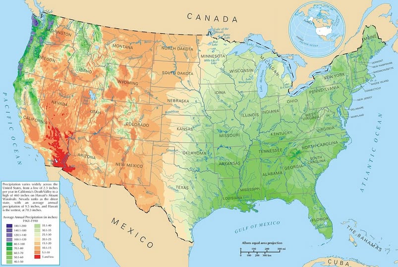
The United States experiences one of the most dramatic ranges of rainfall on Earth, and understanding it helps explain everything from water bills to agriculture to why certain states are dealing with drought right now.
The Dry West: Where Water Is Gold
The western half of the country is, quite simply, thirsty.
Nevada holds the title of driest state in the nation, averaging just 9.5 inches of rain per year. Death Valley in California takes the record for the lowest single location rainfall at just 2.3 inches annually. On the map, these areas show up in deep reds and oranges, a visual reminder that this is desert territory.
Arizona, Utah, and large portions of New Mexico share this arid character. Communities in these states rely heavily on snowmelt from mountain ranges and carefully managed river systems to survive. Every drop genuinely counts out there.
The Pacific Coast: A Tale of Two Climates
Here is where things get interesting. Washington and Oregon, sitting right next to those bone-dry Nevada and Idaho landscapes, are soaking wet.
The Pacific Northwest receives some of the highest rainfall totals in the continental U.S., thanks to moist air rolling in off the Pacific Ocean and dumping that moisture against the Cascade Mountains. You can see the sharp colour change on the map right along the Cascades.
The Lush East: Green for a Reason
Cross the Mississippi River, and the map turns noticeably greener. The southeastern United States, particularly the Gulf Coast states of Louisiana, Mississippi, Alabama, and Florida, receives enormous amounts of rainfall each year. Florida averages well over 50 inches annually, and parts of the Gulf Coast push even higher.
This moisture feeds some of the most productive farmland and richest ecosystems in North America. It is no coincidence that the Deep South has a reputation for dense forests, swamps, and incredibly fertile soil.
The Middle Ground
The Great Plains states sit in a fascinating transition zone. Kansas, Nebraska, and the Dakotas receive moderate precipitation, enough to support wheat and corn farming, but not so much that flooding is a constant concern. This belt of mid-range rainfall is essentially the breadbasket of America.
Why This Matters for Homeowners
If you are thinking about water infrastructure, plumbing, or drainage for your home, your location on this map matters enormously. A house in Tucson needs completely different water management than one in Nashville. Knowing your local precipitation patterns helps you make smarter decisions about everything from gutters to water heaters to irrigation systems.
Water is not evenly distributed across America. But now at least you know where it all goes.
Help us out by sharing this map: