Map by Reddit user MansterSoft
Looking at this fascinating map of America’s top export trading partner by state, one thing becomes crystal clear: geography matters in the age of global commerce, but not always in the ways you’d predict.
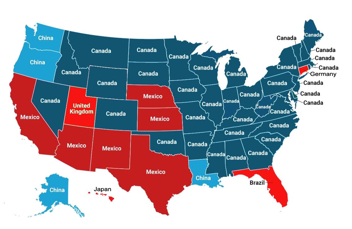
Canada: America’s Trade BFF
The most striking pattern? Canada dominates as the top export partner for the vast majority of U.S. states.
This makes perfect sense when you consider the 5,525-mile border we share and decades of trade agreements like NAFTA (now USMCA). From Montana’s wheat to Michigan’s automotive parts, Canadian consumers and businesses are hungry for American goods.
What’s particularly interesting is how this relationship extends far beyond border states. Even landlocked states like Kansas and Colorado find their biggest export market up north, suggesting that established trade routes and business relationships matter more than pure proximity.
The Mexico Belt: A Strategic Corridor
Mexico claims a significant chunk of the American Southwest and South, which aligns perfectly with both geography and economic logic.
States like Texas, Arizona, and New Mexico share extensive borders with our southern neighbor, but Mexico‘s influence extends surprisingly far north into Colorado and even claims Florida on the opposite coast.
This “Mexico belt” reflects the reality of integrated manufacturing supply chains, particularly in automotive and electronics, where components cross borders multiple times before becoming finished products.
Asia’s American Footholds
Perhaps the most intriguing elements on this map are the unexpected Asian connections.
China appears to dominate exports from Washington state (hello, Boeing aircraft and Pacific ports), Louisiana (likely agricultural products through the Mississippi River system), and Alaska (oil and natural resources make sense here).
Japan’s presence in Hawaii is geographically logical given its Pacific proximity, but it also highlights how island economies often develop specialized trading relationships.
The European Surprise
Germany’s lone presence is a reminder that high-value manufactured goods and specialized industrial equipment can make even distant trading relationships economically viable.
Brazil’s appearance in Florida suggests that Miami’s role as the unofficial capital of Latin America extends to official trade statistics as well.
What This Map Really Shows
This isn’t just about which countries buy the most American stuff, but it’s a visualization of economic relationships built over decades. Trade patterns follow infrastructure, culture, and established business networks as much as they follow pure economic efficiency.
The dominance of Canada and Mexico reflects the success of North American economic integration, while the scattered presence of Asian and European partners shows how specialized industries can create surprisingly strong long-distance trade relationships.
For American workers and businesses, this map is a reminder that your job might depend on relationships with countries you’ve never thought much about, and that economic patriotism increasingly means thinking continentally, not just nationally.
Help us out by sharing this map: