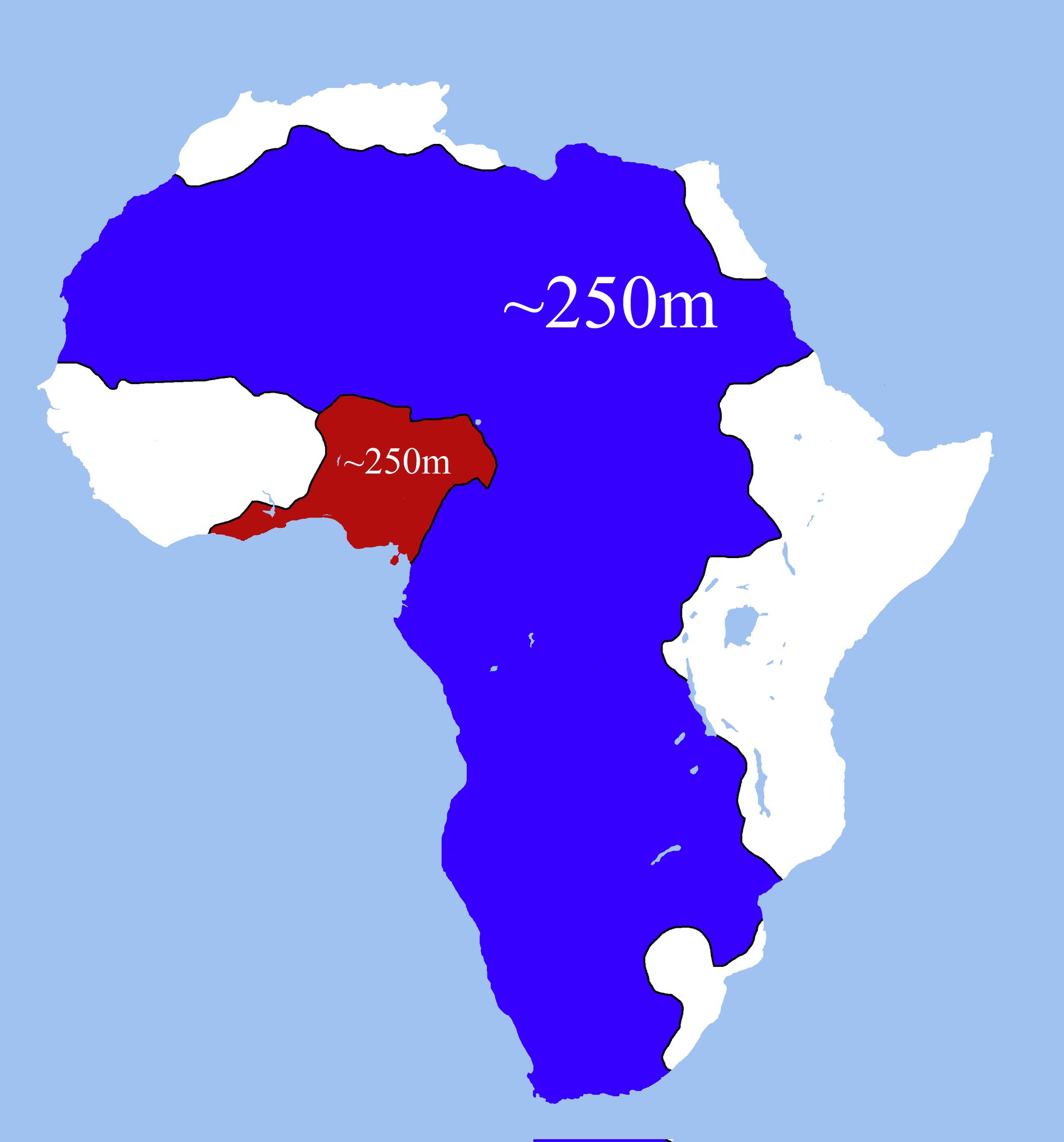
Looking at this map of Africa, you might do a double-take. The massive blue region covering most of the continent has roughly the same population as the small red area in West Africa.
This fascinating demographic reality reveals deeper truths about how geography, climate, and history shape where people choose to live.
The Blue Giant: Vast but Sparsely Populated
The blue region represents an enormous swath of Africa, stretching from the Sahara Desert in the north down through much of East and Southern Africa. Despite covering millions of square kilometers, this massive area struggles with challenges that keep population density low.
Much of this territory includes the Sahara Desert, one of Earth’s most inhospitable environments. Even outside the desert, large portions face water scarcity, extreme temperatures, and soil conditions that make agriculture difficult. The result? Scattered settlements and nomadic populations rather than dense urban centers.
The Red Powerhouse: Small but Densely Packed
The red region in West Africa tells a completely different story. This compact area likely includes parts of Nigeria, which alone has over 200 million people, making it Africa’s most populous country. The region also encompasses parts of Ghana, Ivory Coast, and other West African nations known for their bustling cities and agricultural productivity.
Several factors contribute to this population concentration. The climate supports year-round agriculture, with two rainy seasons in many areas. Major river systems provide water for drinking, irrigation, and transportation. Coastal access has historically made these areas hubs for trade, first across the Sahara and later with European merchants.
Why Geography Still Matters in the Modern World
This population distribution isn’t just a historical curiosity. It has real implications for economic development, political power, and resource allocation across Africa. Countries in the densely populated red region often face challenges with urban overcrowding, while those in the blue region struggle with the costs of providing services across vast, sparsely populated territories.
The contrast also highlights how natural resources and climate continue to influence human settlement patterns, even in our interconnected modern world. While technology can overcome some geographical barriers, fundamental factors like water availability and agricultural potential still play crucial roles in determining where people choose to build their lives.
Understanding these patterns helps explain many of Africa’s contemporary challenges and opportunities, from urbanization pressures to infrastructure development priorities.
Help us out by sharing this map: