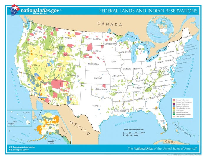
Map from the National Atlas of the United States (Public Domain)
Most Americans assume the land beneath their feet is privately owned. But take a look at this map from the National Atlas of the United States, and you might be genuinely surprised. A huge chunk of the country is owned and managed by federal agencies, and the patterns it reveals tell a fascinating story about history, politics, and conservation.
The West Is a Different World
The most striking thing about this map is the sheer concentration of federal land in the western states. Nevada, Utah, Idaho, Oregon, and Wyoming are absolutely blanketed in color. The Bureau of Land Management (shown in yellow) controls vast stretches of these states, covering everything from high desert to sagebrush plains. The Department of Defense holds significant chunks, too, which explains why you occasionally hear about restricted airspace over Nevada.
Compare that to the eastern half of the country, which is largely white on the map, meaning privately owned. The East was settled and parceled out much earlier, while the West was acquired by the federal government through treaties and purchases and was never fully transferred to private hands.
National Parks and Forests: America’s Crown Jewels
The green shading represents National Park Service land and U.S. Forest Service holdings. You can spot the famous clusters in the Rockies and along the Pacific Coast. These are the lands that give America its reputation for breathtaking wilderness, from Yellowstone to Yosemite. Forest Service land in particular plays a dual role, protecting ecosystems while also allowing some commercial activity like timber harvesting.
Indian Reservations: A Legacy of Complicated History
The pink areas represent Bureau of Indian Affairs land, which includes tribal reservations. You can see significant concentrations in the Southwest (particularly Arizona and New Mexico), the Dakotas, and Montana. These lands represent the outcome of treaties between the U.S. government and Native nations, treaties that were frequently renegotiated or broken under pressure. Today, tribal nations have a complex sovereign relationship with the federal government, and reservation land management remains a deeply important political and cultural issue.
Why Should You Care?
Federal lands affect grazing rights, mining permits, water rights, energy development, and recreational access. When politicians debate drilling in Alaska or expanding national monuments, THIS is the map they are looking at. Understanding who owns what is the foundation for understanding almost every major environmental and resource debate happening in the country right now.
Next time you hear about a land dispute in the news, pull up this map. Chances are, federal ownership is right at the heart of it.
Help us out by sharing this map: