Map found on Reddit
If a picture is worth a thousand words, a map is worth a million data points.
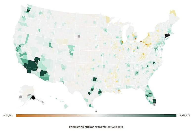
This choropleth map of US population change between 1982 and 2022 tells a fascinating story about where Americans chose to live, work, and raise families over four transformative decades.
The West Coast Surge
The deepest greens on the map congregate along the California coast and into the Southwest. Los Angeles County added nearly three million residents over this period, the largest raw gain of any county in the country.
The Phoenix metro area and Las Vegas corridor are equally striking, reflecting the Sun Belt’s magnetic pull on workers chasing affordable housing and sunshine.
The Rust Belt Reality
Flip your eyes to the upper Midwest and Northeast, and the color palette shifts dramatically. Amber and tan tones wash across parts of Ohio, Pennsylvania, Michigan, and upstate New York.
These are counties that lost population, in some cases quite significantly. Deindustrialisation, an ageing workforce, and the departure of younger generations to coastal cities all contributed to this quiet demographic retreat.
Texas and Florida: The Standout Stories
Both states are lit up in green throughout, but the density of dark patches around Houston, Dallas, Austin, Tampa, and Miami is particularly telling. These metros combined population growth with economic diversification, drawing in both domestic migrants and international newcomers at a remarkable rate.
Florida essentially became a different state by headcount over this window.
The Great Plains: Steady as She Goes
Much of the interior, spanning the Dakotas down through Kansas and Nebraska, sits in near white on the map. This is not necessarily a decline so much as stasis.
Agricultural communities held relatively steady, though rural counties across this belt have quietly been hollowing out for generations as farm consolidation reduced the need for labour.
What This Map Does Not Show
Raw population change numbers can be misleading without context. A small county adding 50,000 people might represent an extraordinary percentage growth, while a large urban county adding the same number barely registers.
This map visualises absolute gains and losses, which is why large, already populated counties dominate the colour extremes.
Why This Matters
Population distribution shapes everything from congressional representation and federal funding to housing markets and infrastructure investment. The counties that grew fastest are now grappling with affordability crises and strained services. Those that shrank face their own set of challenges around tax bases and ageing populations.
Four decades of movement, ambition, and economic reality, all compressed into one quietly compelling image. Worth a longer look.
Help us out by sharing this map: