Map by Reddit user BufordTeeJustice
Most of us know Chile as that impossibly skinny country hugging South America’s western coast. But have you ever really stopped to consider just how absurdly long it is?
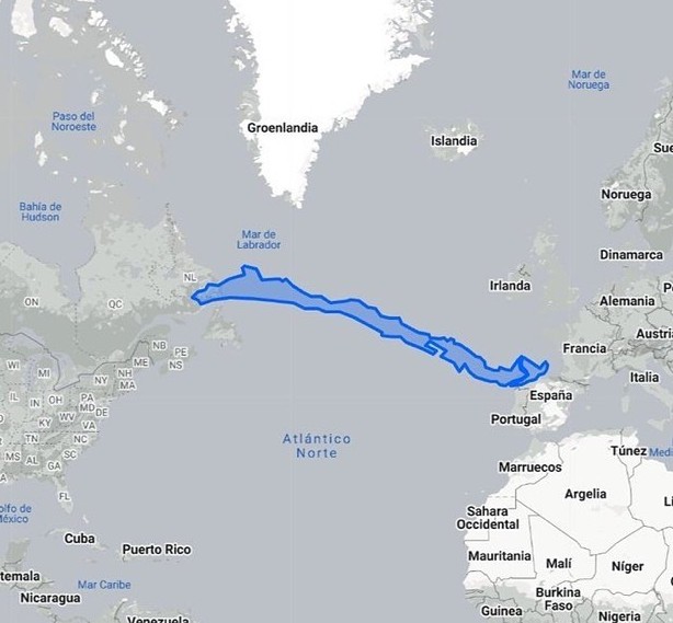
The image above rotates Chile 90 degrees and lays it across the Atlantic Ocean, revealing something remarkable: this single nation could stretch from the coast of Spain all the way to the maritime provinces of Canada.
That’s not a trick of perspective. Chile really is that long.
The Numbers That Make You Double-Take
Chile extends roughly 4,300 kilometers from north to south. To put that in perspective, it’s like driving from New York City to Los Angeles, except you never leave the same country.
The nation spans 38 degrees of latitude, which means traveling from one end to the other takes you through practically every climate zone imaginable.
Meanwhile, Chile averages only about 180 kilometers in width. This creates one of the most extreme length-to-width ratios of any country on Earth. If countries had body types, Chile would be doing runway modeling.
From Desert to Glacier Without Leaving Home
This extraordinary length gives Chile an environmental diversity that few nations can match. The north contains the Atacama Desert, one of the driest places on the planet, where some weather stations have never recorded rainfall.
The center enjoys a Mediterranean climate perfect for wine production. The south features temperate rainforests that eventually give way to Patagonian ice fields and the windswept channels near Cape Horn.
Chileans living in Arica near the Peruvian border experience a completely different country than those in Punta Arenas near Antarctica. The distance between these cities is greater than the distance between London and Baghdad.
Why Geography Matters
Understanding Chile’s length helps explain much about its history and culture. The country developed somewhat isolated from its neighbors, protected by the Andes Mountains to the east and the Pacific Ocean to the west. This geographic reality shaped everything from its political development to its unique Spanish dialect.
The comparison to the Atlantic crossing also highlights something else: how our mental maps of the world can deceive us. We tend to think of South American countries as relatively compact, but Chile breaks that mold spectacularly. It’s a reminder that our planet contains geographic quirks that challenge our assumptions and reward closer examination.
Help us out by sharing this map: