Picture this: it’s around 600 BC, and while most people’s idea of the world extends barely beyond their local village, one brilliant Greek philosopher is sketching out the entire known world on a bronze tablet.
Meet Anaximander of Miletus, the man who created what many scholars consider the first true world map.
The Revolutionary Mapmaker from Miletus
Anaximander wasn’t your typical ancient Greek thinker pondering abstract philosophy in a garden. Born around 610 BC in the bustling port city of Miletus (in modern-day Turkey), he was a practical visionary who combined deep thinking with real-world problem solving.
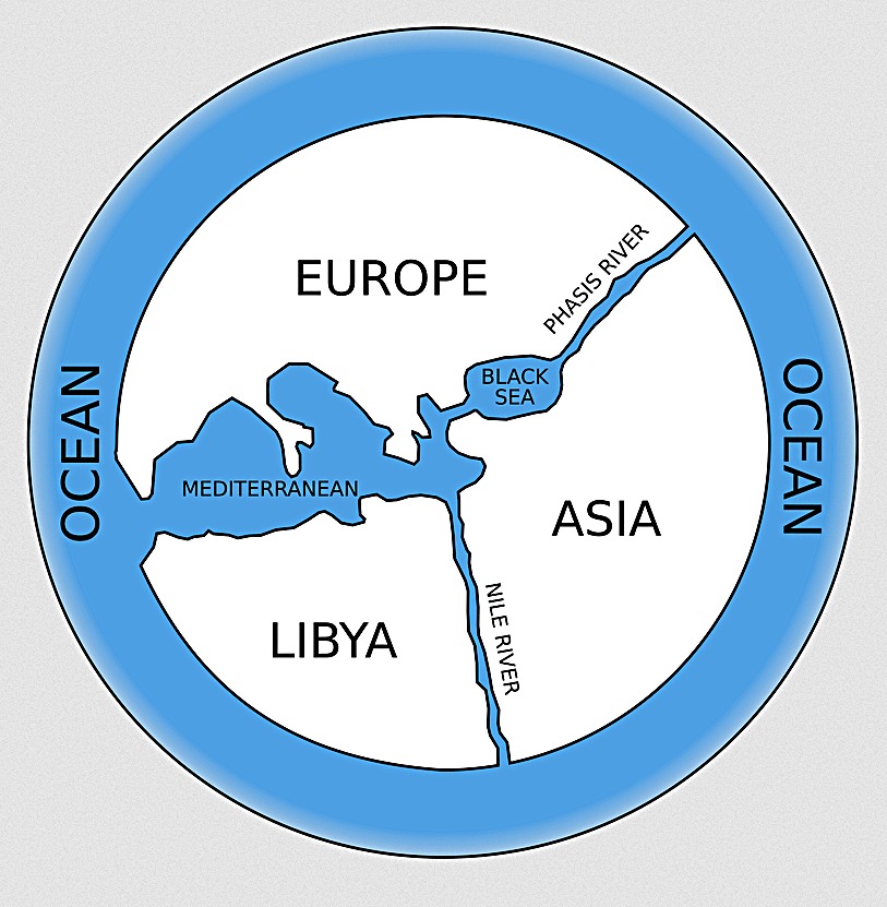
The Greek philosopher Anaximander of Miletus (l. c. 610 to c. 546 BCE) is credited with having drawn the first map of the world, which was circular in form and showed the three continents of Europe, Asia, and Libya (Africa) surrounded by the great world ocean.
What made his approach groundbreaking wasn’t just that he drew a map, but how he thought about the world itself.
Anaximander was the first to postulate that the earth floated freely on what was known as the “infinite,” a substance different from the four elements of fire, earth, air, and water. This was radical thinking for its time.
Why Create the World’s First Map?
Anaximander most likely drew this map to improve navigation and trade between Miletus and other colonies. Miletus was a major trading hub, and accurate geographical knowledge meant better business.
Ships needed to know where they were going, and merchants needed to understand the relationships between different regions. Anaximander’s map served as an ancient GPS system, helping Greek traders navigate the complex waters of the Mediterranean and Black Sea.
What the Map Actually Looked Like
Unfortunately, Anaximander’s original bronze tablet hasn’t survived the millennia. But ancient historians like Herodotus saw similar maps and described them for us.
The map showed three continents: Europe, Asia, and Libya (what we now call Africa), all surrounded by a great ocean. Anaximander placed the Aegean and Miletus at the centre of his map. This wasn’t just geographical convenience – it reflected how the Greeks saw themselves as the center of the civilized world.
Key features included the Mediterranean Sea, the Black Sea, and major rivers like the Nile and Phasis (modern-day Rioni River in Georgia), which served as natural boundaries between continents.
The Map’s Lasting Impact
Anaximander’s work didn’t exist in isolation. The map most likely inspired the Greek historian Hecataeus of Miletus to draw a more accurate version. Strabo viewed both as the first geographers after Homer. This created a chain of geographical knowledge that would eventually lead to more sophisticated mapping techniques.
The first Greek map of the world is much more complete and accurate, probably thanks to the Greeks’ extensive maritime trade networks. Unlike the Babylonians, who were primarily a land-based civilization, the Greeks had ships constantly crossing the Mediterranean, gathering real-world geographical data.
From Philosophy to Practical Geography
What makes Anaximander’s achievement so remarkable is how it bridged the gap between abstract thinking and practical application.
By drawing a map of the world, he was the first geographer. But above all, by boldly speculating about the universe, he broke with the ancient image of the celestial vault and became the discoverer of the Western world-picture.
Help us out by sharing this map: