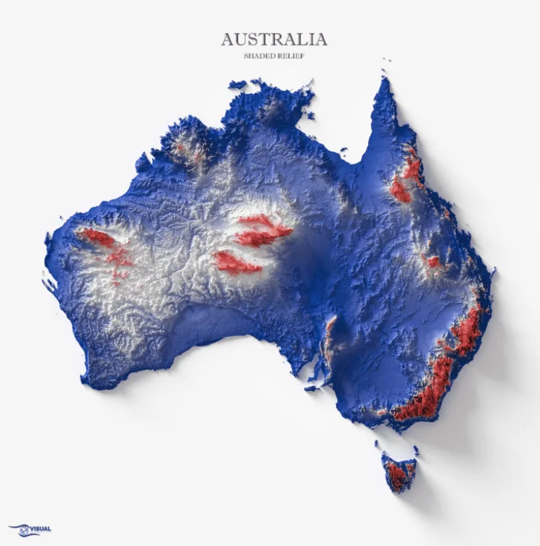
This is a relief map of Australia, showcasing its various land features.
The country, which is also the world’s smallest continent, has a total land area of 2,988,902 square miles (7,741,220 square kilometers), according to ThoughtCo.
Lowlands and plains (in blue) dominate the central and eastern parts of the Commonwealth nation. Areas with medium (white) to high (red) elevation are prevalent in the rest of the country.
Located among the mountain ranges in the mainland’s southeast, Mount Kosciuszko is Australia’s highest peak. Situated in the border between the states of New South Wales and Victoria, the peak stands at 7,310 feet (2,228 meters) tall, according to Britannica. It is also only one of among a few points in the country that have a 2,000 ft (600 m) high elevation.
Help us out by sharing this map:
Your article helped me a lot, is there any more related content? Thanks! https://www.binance.info/register?ref=IHJUI7TF
Can you be more specific about the content of your article? After reading it, I still have some doubts. Hope you can help me. https://accounts.binance.info/register-person?ref=IXBIAFVY
Thanks for sharing. I read many of your blog posts, cool, your blog is very good.
Hurrah! In the end I got a blog from where I can genuinely take useful facts regarding my study and knowledge.
I don’t think the title of your article matches the content lol. Just kidding, mainly because I had some doubts after reading the article. https://www.binance.com/register?ref=IXBIAFVY
I don’t think the title of your article matches the content lol. Just kidding, mainly because I had some doubts after reading the article.
Thanks for sharing. I read many of your blog posts, cool, your blog is very good. binance referral bonus
Thank you for your sharing. I am worried that I lack creative ideas. It is your article that makes me full of hope. Thank you. But, I have a question, can you help me? https://www.binance.com/es/register?ref=RQUR4BEO
Can you be more specific about the content of your article? After reading it, I still have some doubts. Hope you can help me.
Your article helped me a lot, is there any more related content? Thanks! https://www.binance.bh/futures/ref?code=QCGZMHR6
Can you be more specific about the content of your article? After reading it, I still have some doubts. Hope you can help me. https://www.binance.bh/es-AR/register?ref=UT2YTZSU