Map by Reddit user cjfallinfaw07
If you’ve ever looked at a map of Croatia, you might have noticed something peculiar. The country has one of the most unusual shapes in Europe, stretching along the Adriatic coast like a boomerang.
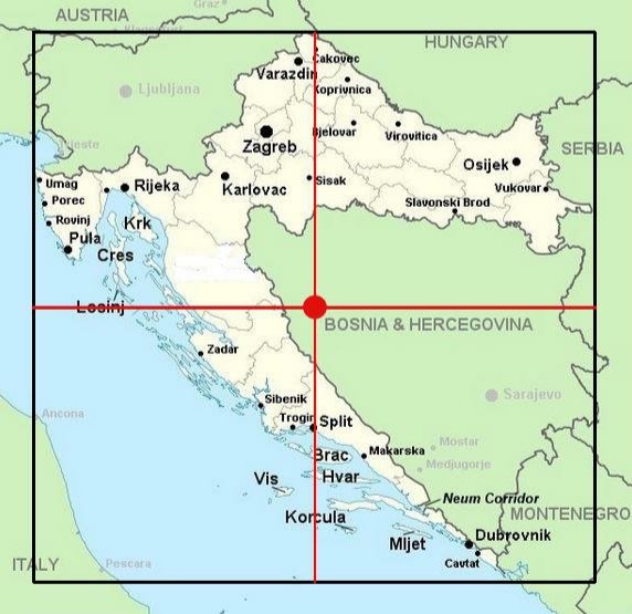
But here’s the kicker: because of this distinctive shape, the actual geographic center of Croatia isn’t even in Croatia. It’s in neighboring Bosnia and Herzegovina.
The Shape That Changed Everything
Croatia’s unique configuration is the result of centuries of complex political history.
The country wraps around Bosnia and Herzegovina, creating a thin coastal strip that extends south to Dubrovnik. This coastal territory, historically part of the Dalmatian region, meant that when modern borders were drawn, Croatia ended up with a shape that defies conventional geography.
The mathematical center of any territory is calculated by finding the average position of all its points. When you do this calculation for Croatia, considering its northern regions near Zagreb, its eastern territories, and that long coastal stretch, the geometric midpoint falls just across the border in Bosnia and Herzegovina.
More Common Than You’d Think
Croatia isn’t alone in this geographic oddity. Several countries around the world have their centers located outside their borders.
The phenomenon typically occurs with nations that have irregular shapes, enclaves, or far-flung territories. What makes Croatia particularly interesting is how visible this quirk is on any map. You don’t need to be a cartographer to see why the math works out this way.
What This Actually Means
In practical terms, this geographic curiosity doesn’t change much for either country. It’s more of a fun fact than a political issue.
The actual spot where Croatia’s center falls isn’t marked with any special monument or tourist attraction. It’s simply a mathematical point that highlights how political boundaries and geometric calculations don’t always align neatly.
A Reminder of Complex Histories
This geographic oddity serves as a subtle reminder of the Balkans’ intricate history. The borders we see today reflect centuries of empires, kingdoms, and more recent conflicts. The shape of Croatia tells a story of Venetian influence along the coast, Ottoman expansion inland, and the complicated process of nation-building in southeastern Europe.
For travelers exploring the region, this quirk adds another layer of intrigue to an already fascinating area. Whether you’re island hopping along the Dalmatian coast or exploring the continental regions near Zagreb, you’re experiencing a country whose very shape defies simple description.
Next time someone pulls out a map of Europe, you’ll have the perfect conversation starter. Croatia’s geographic center might be in another country, but that only makes this beautiful nation more interesting.
Help us out by sharing this map: