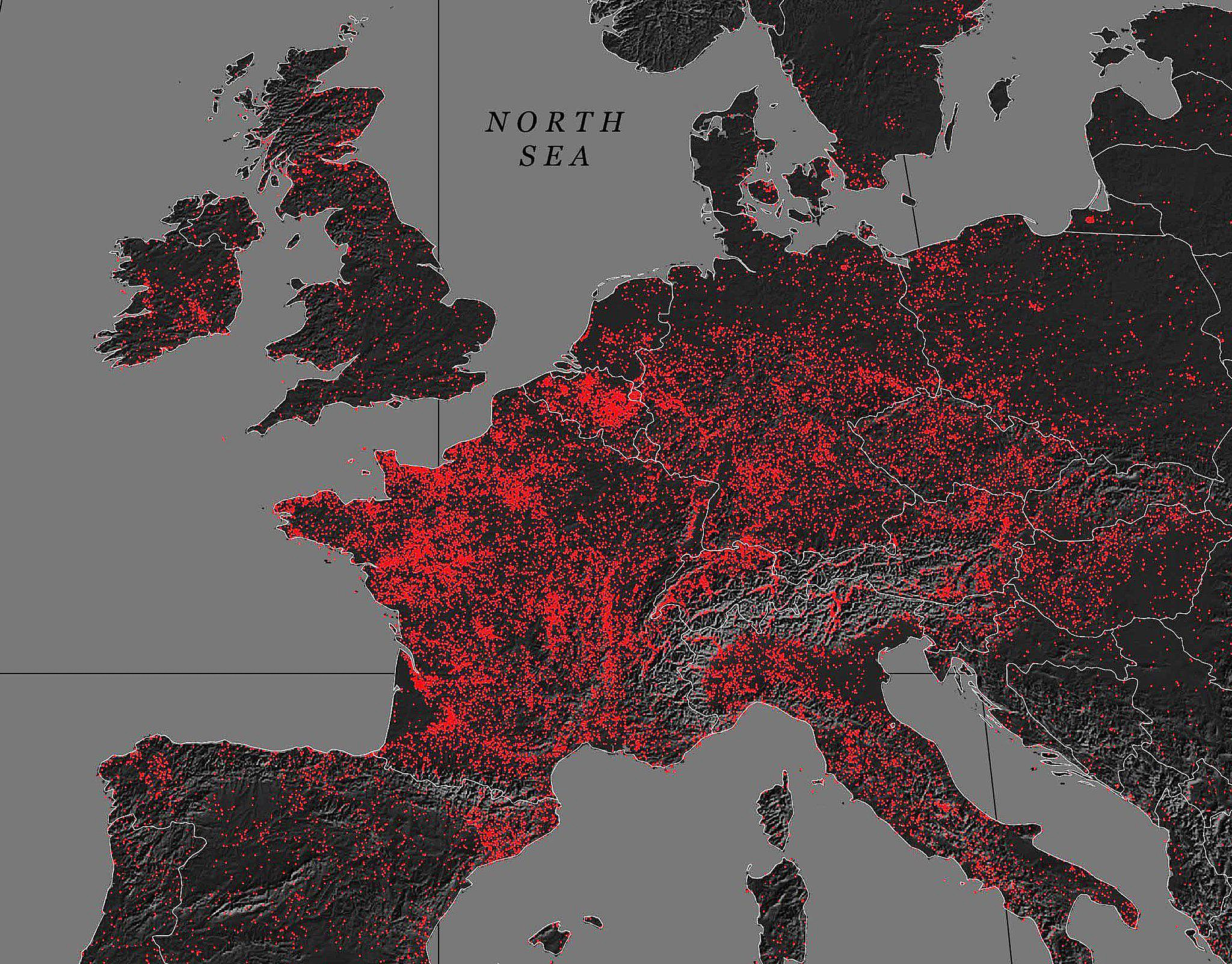
Map by Reddit user MardukSyria
Looking at this striking visualization of European castle distribution, one thing becomes immediately clear: medieval Europe was absolutely bristling with fortifications.
The red dots scattered across the continent represent an estimated 40,000 castles, each one telling a story of power, protection, and political maneuvering that shaped the world we know today.
France: The Undisputed Castle Capital
The most obvious pattern jumping from this map is France’s incredible concentration of castles. The entire country glows red like a medieval Christmas tree, and for good reason.
France’s feudal system created perfect conditions for castle building. Local lords needed defensive strongholds to protect their territories, while the fragmented political landscape meant constant border disputes and power struggles.
From the Loire Valley’s fairy tale châteaux to the defensive fortresses of the Pyrenees, France built castles like other countries built barns.
Germany’s Strategic Corridor
Germany shows another fascinating pattern, with castles clustering heavily along river valleys and mountain passes.
The Holy Roman Empire’s complex political structure meant hundreds of independent duchies, bishoprics, and free cities all needed their own defensive positions. The Rhine Valley, in particular, became known as one of the most castle-dense regions in the world, with fortifications perched on nearly every strategic hilltop.
Britain’s Coastal Defense Network
Across the English Channel, Britain displays a more restrained but equally strategic approach. English castles cluster heavily along the Welsh and Scottish borders, telling the story of centuries of conflict and consolidation.
The Norman Conquest of 1066 triggered a massive castle-building program as new overlords established control over a sometimes reluctant population.
The Quiet North and East
Scandinavia’s relative scarcity of castles reflects different defensive traditions and political structures. The Vikings preferred mobile warfare and fortified towns rather than static stone fortresses.
Meanwhile, Eastern Europe’s pattern varies dramatically, with some regions showing dense concentrations while others remain remarkably sparse, often reflecting the ebb and flow of various empires and the different approaches to territorial control.
More Than Just Military Architecture
These weren’t just military installations. Medieval castles served as administrative centers, economic hubs, and symbols of prestige. They controlled trade routes, collected taxes, and projected power across the landscape. Each dot on this map represents not just stone and mortar, but the ambitions, fears, and strategic thinking of medieval rulers.
This remarkable distribution reveals how geography, politics, and warfare combined to create one of history’s most distinctive architectural legacies. Every castle had its story, and together they wrote the complex narrative of medieval European civilization.
Help us out by sharing this map: