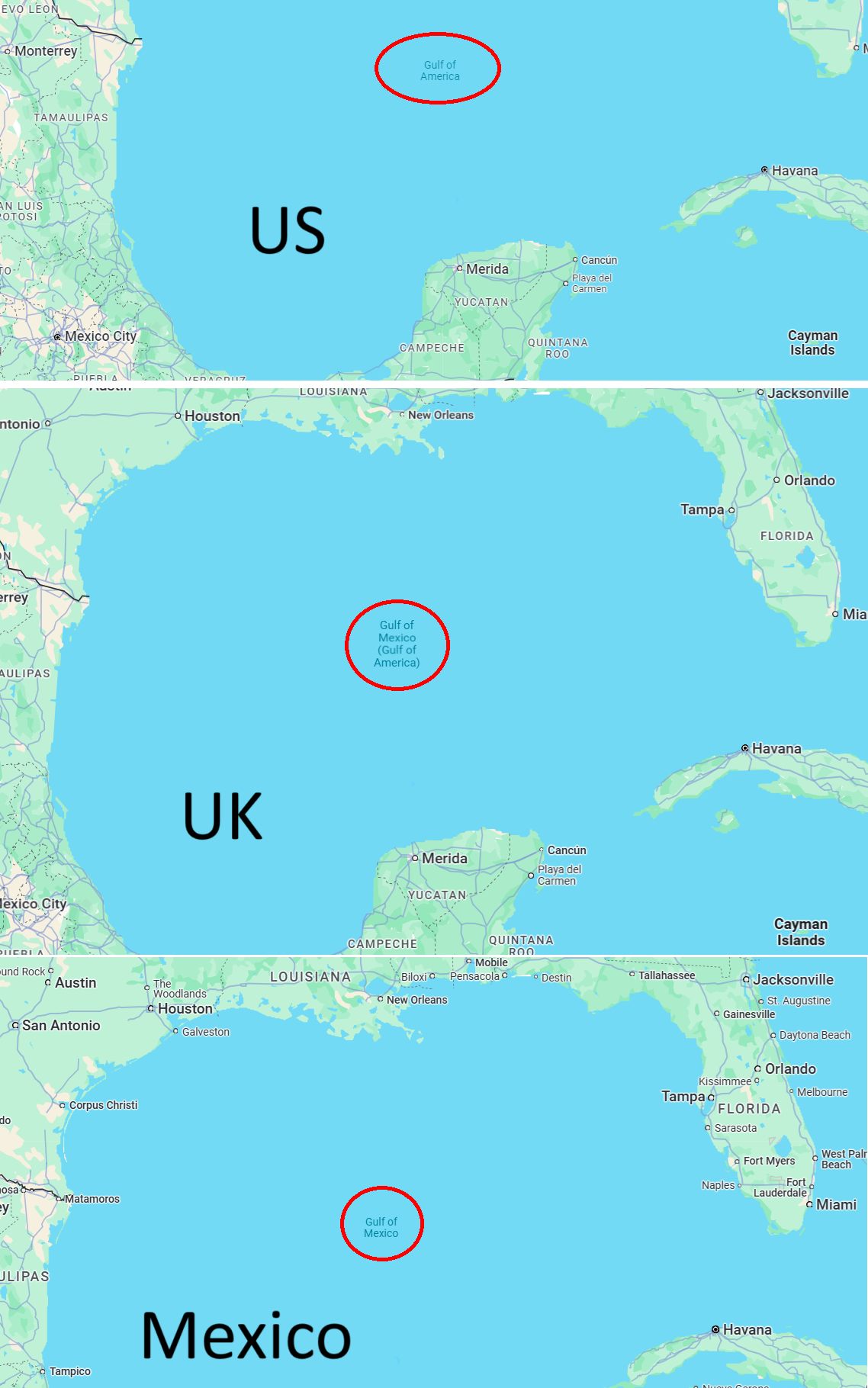
Ever wondered why the same body of water might have different names depending on where you’re looking at it from? The image above perfectly illustrates this fascinating phenomenon, showing how Google Maps displays the Gulf of Mexico differently based on your location. This isn’t just a technical quirk; it’s a window into the complex world of digital diplomacy and geographic politics.
What’s Really Happening Here
The user’s location determines how a digital map is labeled. Google Maps users in the U.S. see Gulf of America, while Google Maps users in Mexico still see Gulf of Mexico.
Users in other countries will see both names. This change came about after President Trump signed an executive order in January 2025 renaming the Gulf of Mexico to the Gulf of America during his first week in office.
The Technical Side of Geographic Naming
Google’s Geographic Names Information System (GNIS) has officially updated “Gulf of Mexico” to “Gulf of America” for U.S. users. But this isn’t just Google making arbitrary decisions.
Popular map services such as Google Maps, Apple Maps and Bing Maps have all changed the Gulf of Mexico to the Gulf of America in the U.S.
The technology behind this is actually quite sophisticated. Map services use geolocation to determine where you’re accessing the service from, then serve up the locally appropriate version of geographic names.
It’s the same reason why you might see the “Persian Gulf” in some countries and the “Arabian Gulf” in others.
Why This Matters More Than You Think
This isn’t the first time we’ve seen geographic naming disputes play out in the digital realm. This isn’t the first body of water to have different names according to different countries. Bodies of water, mountain ranges, and even cities often have different names depending on political perspectives and historical claims.
What’s particularly interesting about the Gulf situation is how it highlights the intersection of national sovereignty and international waters.
Although there is no formal protocol on the general naming of international waters, Gulf of Mexico is officially recognized by the International Hydrographic Organization, which seeks to standardize the names of international maritime features.
The Bigger Picture
This map controversy reveals something fascinating about our digital age: the same geographic reality can be presented differently to different audiences simultaneously. While the physical body of water remains unchanged, our digital representations of it adapt to local politics and preferences.
For Americans, this means when you’re planning that fishing trip to what you now see labeled as the “Gulf of America,” you’re witnessing a real-time example of how technology companies navigate the complex waters of international relations. Meanwhile, your friends in Mexico are still seeing it as the Gulf of Mexico on their devices.
Looking Forward
As our world becomes increasingly digital, these kinds of localized geographic naming will likely become more common. Map services are essentially serving as diplomatic intermediaries, trying to respect local preferences while maintaining functionality across borders.
The next time you’re looking at a map, remember: you’re not just seeing geography; you’re seeing geography filtered through the lens of where you happen to be standing in the world.
Help us out by sharing this map: