Map by Citypeek / Wikimedia Commons
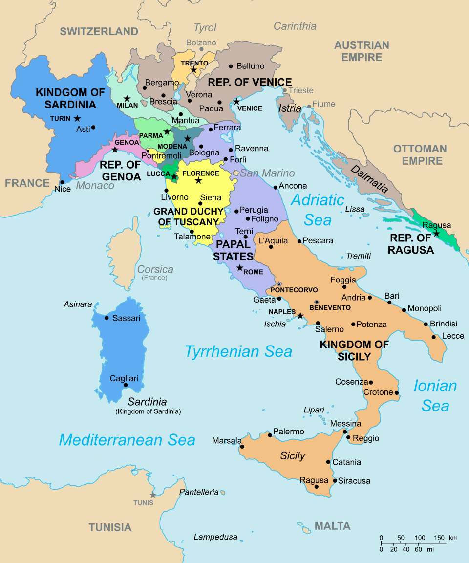
Looking at Italy in 1796 is like examining a complex jigsaw puzzle where each piece tells its own story.
This fascinating map reveals a peninsula divided into numerous independent states, kingdoms, and republics, each with distinct borders, rulers, and allegiances.
Far from the unified nation we know today, Italy was a tapestry of competing powers that would remain fragmented for another 65 years.
Northern Powerhouses and Maritime Republics
The northern regions showcase some of Europe’s most influential city-states and kingdoms.
The Kingdom of Sardinia, colored in blue, controlled substantial territory including Turin, the future capital of unified Italy. Meanwhile, the Republic of Venice maintained its centuries-old maritime empire, stretching from the lagoons of Venice itself to territories along the Adriatic coast.
The Republic of Genoa, though smaller than its Venetian rival, remained a significant maritime power controlling crucial Mediterranean trade routes. These northern states represented wealth, trade connections, and political sophistication that would prove essential during the later unification movement.
The Papal States: Spiritual and Temporal Power
Dominating central Italy, the Papal States controlled vast territories from Rome northward, including important cities like Bologna and Perugia.
This ecclesiastical state represented one of the most significant obstacles to Italian unification, as the Pope wielded both spiritual authority over Catholics worldwide and temporal power over millions of Italian subjects.
The strategic position of the Papal States effectively divided northern and southern Italy, creating a barrier that ambitious rulers would need to navigate carefully in future decades.
Southern Kingdoms and Island Realms
The Kingdom of Sicily encompasses both the island itself and much of southern mainland Italy, including Naples.
This large southern kingdom represented a different political and economic reality from the more commercialized north, with feudal structures still deeply embedded in society.
Sardinia appears as part of the broader Kingdom of Sardinia, while Corsica belongs to France, highlighting how even islands in the Italian sphere were subject to foreign control.
Foreign Influence and Future Transformation
This 1796 snapshot captures Italy just before Napoleon’s campaigns would dramatically reshape the peninsula. Austrian influence loomed large in the northeast, while French power was expanding from the west. These foreign pressures would soon trigger a series of political upheavals that ultimately contributed to the eventual Risorgimento movement.
Understanding this fragmented Italy helps explain why unification proved so challenging and why regional identities remain strong even today. Each colored territory on this map represents distinct cultures, dialects, and political traditions that had developed over centuries of independence.
Help us out by sharing this map: