Map found on the Asia Maritime Transparency Initiative
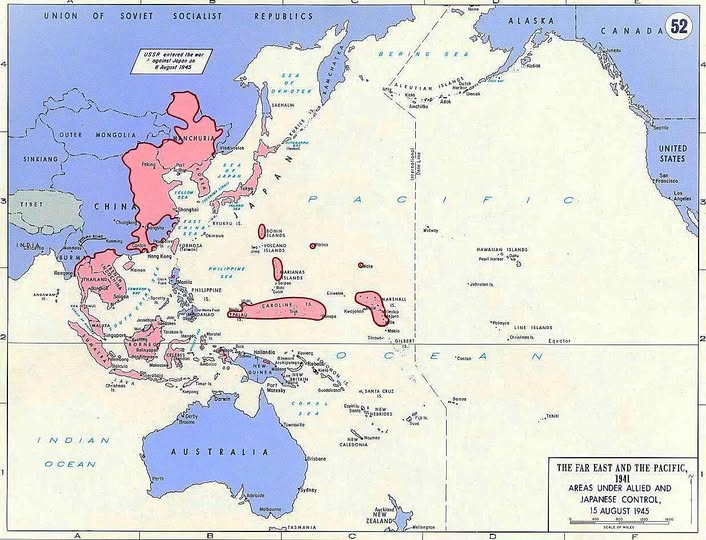
This remarkable map, labeled “The Far East and the Pacific: Areas Under Allied and Japanese Control, 15 August 1945,” captures one of history’s most dramatic reversals of fortune frozen at a single moment in time.
That date is no accident. August 15, 1945 was the day Japan announced its surrender, effectively ending World War II in the Pacific.
Pink Doesn’t Lie
The shading tells the story instantly. The deep pink zones show territory under Japanese control at the war’s peak, stretching from Manchuria in the north, through coastal China, down through Southeast Asia, and fanning out across an enormous sweep of Pacific islands.
At its height, Japan controlled roughly 7 million square miles of land and ocean. It was one of the most audacious territorial grabs in modern history, executed with terrifying speed between 1937 and 1942.
The lighter pink remnants visible by August 1945 show how dramatically that empire had shrunk. The Allied island-hopping campaign, combined with devastating air power and strangled supply lines, had carved the empire apart piece by piece.
The USSR Note Worth Noticing
A small but significant annotation sits in the upper left corner: “USSR entered the war against Japan on 8 August 1945.” Easy to miss, hugely important.
Just days before Japan’s surrender, the Soviet Union launched a massive invasion of Japanese-held Manchuria. This two-front pressure, combined with the atomic bombs dropped on Hiroshima and Nagasaki, made continued Japanese resistance essentially unthinkable.
What the Pacific Islands Reveal
Look at the Caroline Islands, the Marianas, and the Marshall Islands scattered across the middle of the map. These tiny specks of land were fought over with extraordinary ferocity. Controlling them meant controlling the airfields and supply routes that determined who owned the Pacific.
American victories at Midway, Guadalcanal, and later Iwo Jima and Okinawa progressively dismantled Japan’s defensive perimeter, bringing US bombers within range of the Japanese home islands.
A Snapshot of an Ending World
What makes this map genuinely haunting is its timestamp. By the time it was printed, the old order it depicts was already gone. The colonial map of Asia was about to be redrawn entirely. Independence movements across Southeast Asia, empowered partly by witnessing European and American forces humiliated by Japan earlier in the war, would reshape the entire region over the following decades.
Maps like this one remind us that empires which look permanent on paper can dissolve with shocking speed when the underlying conditions shift. Japan built its Pacific empire in years. It lost it even faster.
Help us out by sharing this map: