Map by Reddit user ixohoxi
Ever seen a city that looks like it was designed by someone with a serious case of OCD? Welcome to La Plata, Argentina, where urban planning took geometry class very, very seriously.
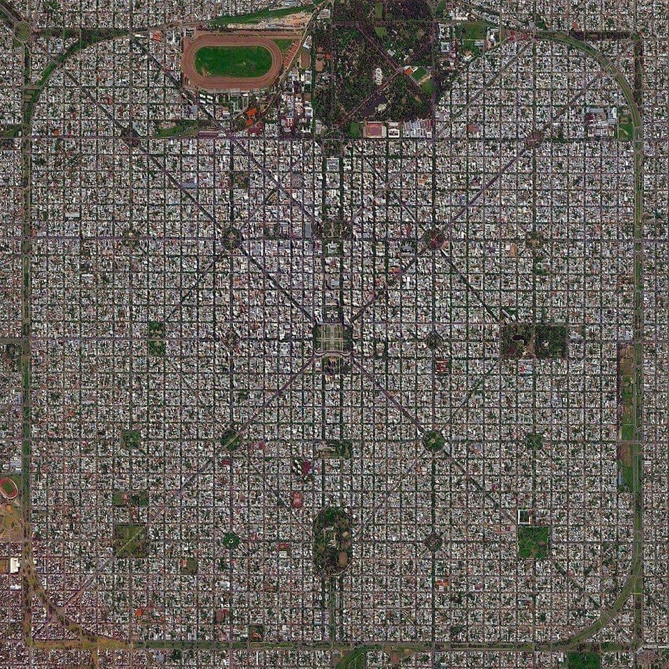
From a satellite view, this Argentine city looks less like an organic settlement and more like someone dropped a perfectly ruled grid onto the landscape. And that’s exactly what happened.
But unlike most planned cities that eventually grow into chaotic sprawls, La Plata stuck to the script.
Born from a Blueprint
La Plata wasn’t always the capital of Buenos Aires Province. When Buenos Aires city itself became the federal capital in 1880, the province suddenly found itself without a seat of government.
The solution? Build a brand new capital from scratch.
Architect Pedro Benoit and urban planner Julio Dormal designed La Plata in 1882 with Enlightenment ideals and a T-square. Their vision was radical for the time: a city built on perfect diagonals intersecting with a strict grid pattern, punctuated by plazas every few blocks.
The result is what you’re seeing here, a city that looks like it could double as a motherboard.
Why So Serious About Straight Lines?
The obsessive geometry wasn’t just aesthetic. Those diagonal avenues cutting through the grid serve a practical purpose: they speed up transit across the city.
Instead of making endless right turns, you can zoom diagonally from one corner to another. It’s like having cheat codes for city navigation.
The regular spacing of parks and plazas was equally intentional. Every neighborhood was designed to have green space within walking distance.
In the 1880s, this was revolutionary urban thinking. Today, it’s what every city planner wishes they could achieve.
The City That Time Couldn’t Mess Up
Here’s what’s truly impressive: despite being over 140 years old, La Plata has largely maintained its original design. While most cities gradually blur their plans through decades of haphazard development, La Plata kept its shape.
Those dark tree-lined avenues you see cutting through the blocks? Those were part of the original 1882 design.
The central axis runs through the image, connecting major institutional buildings. At the top, you can spot a stadium and sports complex. Throughout the grid, regular open spaces break up the urban fabric, exactly as Benoit intended over a century ago.
More Than Just Pretty Patterns
Today, La Plata is home to over 650,000 people who live and work within this geometric marvel. It’s also a major university city, hosting the National University of La Plata, one of Argentina’s most prestigious institutions.
The city proves that rigid planning doesn’t have to mean sterile living. Within that perfect grid, you’ll find vibrant neighborhoods, thriving commercial districts, and a cultural scene that punches well above its weight class.
So next time someone tells you that organic urban growth is always better than planned development, show them this image. Sometimes, a little obsessive organization creates something truly beautiful.
Help us out by sharing this map: