Map by Reddit user utioniaboi
Remember staring at world maps in school and thinking South America looked pretty average-sized? Well, prepare to have your geographic assumptions completely demolished.
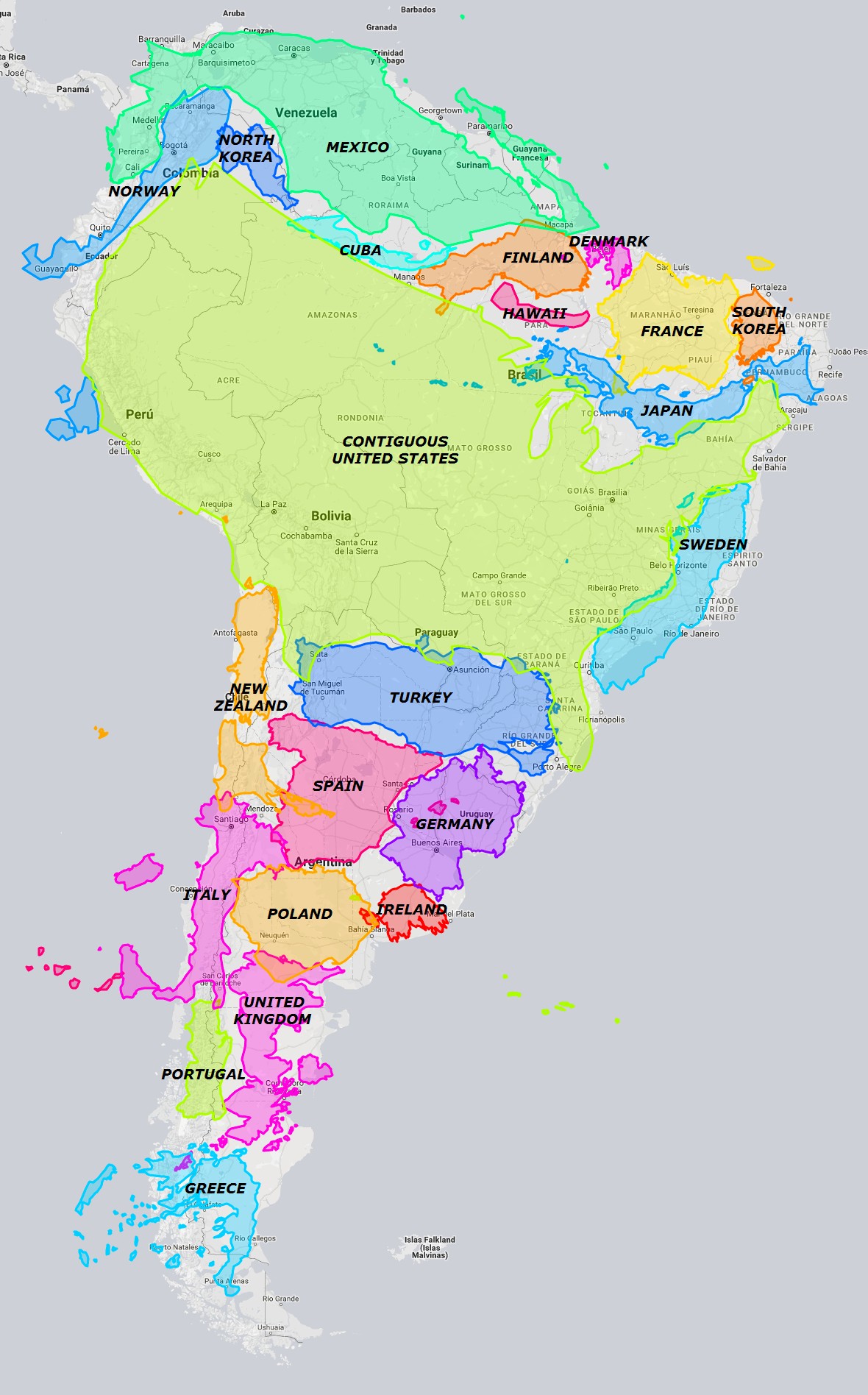
This incredible visualization shows just how massive South America really is by overlaying various countries at their true scale across the continent.
The Mercator Deception
Most world maps use the Mercator projection, which dramatically distorts size as you move away from the equator. Countries near the poles appear inflated, while equatorial regions get shortchanged.
South America sits right in that sweet spot where it gets seriously underrepresented on traditional maps.
What you’re seeing here isn’t some cartographic magic trick. This is cold, hard geographic reality: South America spans roughly 6.9 million square miles, making it the fourth largest continent by land area.
Mind-Blowing Size Comparisons
Look at how the United States fits comfortably within South America’s borders with room to spare. The entire contiguous US could slide into South America, and you’d still have space left over for additional countries.
Even more jaw-dropping? Check out how European nations stack up. The United Kingdom, Germany, France, Spain, Italy, and Poland all find cozy spots within South America’s vast expanse. You could literally fit most of Western Europe inside this single continent.
Beyond Just Land Mass
This isn’t just about bragging rights or geographic trivia. Understanding South America’s true scale helps explain its incredible diversity. With an area this massive, you get everything from Amazon rainforests to Patagonian glaciers, from Caribbean coastlines to Andean peaks.
The continent stretches from about 12°N to 55°S latitude, crossing the equator and spanning multiple climate zones. No wonder it contains such staggering biodiversity and cultural variety.
Why This Matters
These visualizations matter because they reshape how we think about global geography and regional importance. South America isn’t just another continent; it’s a geographic giant that plays a crucial role in global climate, biodiversity, and natural resources.
Next time someone mentions South America, you’ll know they’re talking about a landmass so enormous it could accommodate most of the world’s developed nations simultaneously. Pretty impressive for a continent that gets surprisingly little attention in global discussions.
The next time you glance at a world map, remember: South America is the quiet giant that’s been hiding in plain sight all along.
Help us out by sharing this map: