Map by Reddit user vladgrinch
When John Hancock boldly signed the Declaration of Independence with his famous flourish, he wasn’t signing for the sprawling nation we know today.
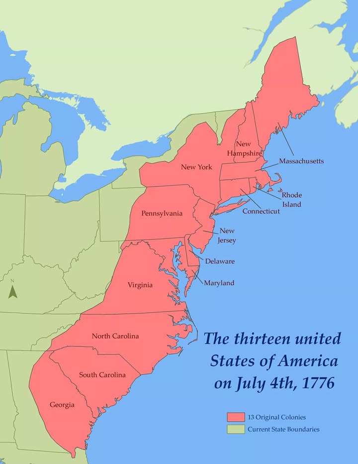
The America of July 4th, 1776 was a much smaller affair: thirteen distinct colonies hugging the Atlantic coastline, each with its own personality and colonial charter.
A Coastal Nation Born from Revolution
Looking at this fascinating map, you can see just how different the United States was at its birth.
The entire nation consisted of a narrow strip of territory along the Eastern seaboard, stretching from the pine forests of New Hampshire down to the rice plantations of Georgia. Everything west of these colonies remained largely unexplored wilderness, controlled by Native American tribes, European powers, or simply unknown.
The red shaded areas show you exactly what the Founding Fathers were fighting for when they declared independence from Britain. Notice how compact everything was compared to today’s continental empire.
These thirteen colonies contained roughly 2.5 million people, about the same population as modern-day Chicago.
From North to South: The Original Lineup
Starting from the top, New Hampshire served as the northernmost colony, while Georgia anchored the southern end. Each colony brought something unique to the revolutionary table.
Massachusetts contributed radical thinkers like Samuel Adams, Pennsylvania offered the practical wisdom of Benjamin Franklin, and Virginia provided military leadership through George Washington.
The geographic clustering is interesting, too.
The New England colonies (Massachusetts, New Hampshire, Connecticut, and Rhode Island) formed a tight-knit group in the northeast. The Middle Colonies (New York, New Jersey, Pennsylvania, and Delaware) occupied the central region, while the Southern Colonies (Maryland, Virginia, North Carolina, South Carolina, and Georgia) stretched down the coast.
What This Map Reveals About Early America
This historical snapshot reveals several fascinating truths about revolutionary America. First, the new nation was entirely dependent on Atlantic trade and coastal commerce. Every major city and economic center sat within reach of ocean-going vessels.
Second, the western boundary of these colonies was much closer than you might expect. The Appalachian Mountains formed a natural barrier that few colonists had crossed. The vast territories that would become Ohio, Kentucky, Tennessee, and everything beyond remained frontier lands.
The Foundation of Something Bigger
What strikes you most about this map is how it captures a moment of incredible potential. These thirteen colonies, small as they appear, contained the seeds of a continental nation. Within a century, this coastal collection would stretch from sea to shining sea.
The men who signed that declaration in Philadelphia could hardly have imagined their small rebellion would eventually encompass fifty states. Yet here, in this simple arrangement of thirteen colonies, lay the foundation of the American experiment that continues today.
Help us out by sharing this map: