Map by the USDA Natural Resources Conservation Service (Public domain)
Most of us grew up with flat, color-coded maps of the United States that told us where states began and ended.
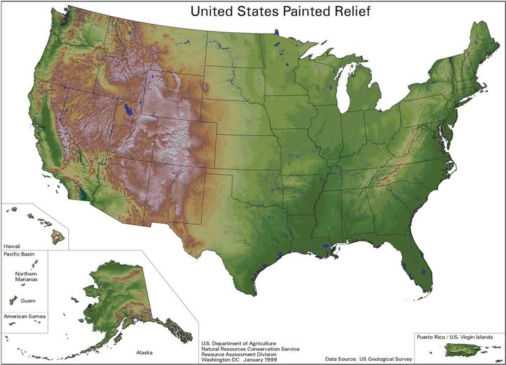
But this stunning painted relief map from the US Geological Survey tells a completely different story. It shows the shape of America, and once you see it, you cannot unsee it.
What Exactly Is a Painted Relief Map?
A painted relief map uses shading, color gradients, and elevation data to simulate how the land would look from above if you were a bird flying at high altitude.
Browns and tans represent high, arid elevations. Rich greens signal lower, lusher terrain. The result is something that feels more like a satellite photograph than a traditional map.
This particular version was produced by the USDA Natural Resources Conservation Service in January 1999, drawing on USGS data. It remains one of the most visually satisfying representations of American geography ever made.
The Rocky Mountain Backbone
The first thing your eye jumps to is the dramatic brown and purple mass running through the western third of the country. This is the Rocky Mountain system, and it is genuinely enormous. The Colorado Plateau, the Sierra Nevada, the Cascades, and the Basin and Range province of Nevada all crowd together here, creating a landscape of staggering complexity.
Notice how abruptly the terrain flattens as you move east past the Rockies. The Great Plains are almost unnervingly flat by comparison.
The Green, Wrinkled East
The eastern half of the country looks gentler but is not entirely flat. You can clearly trace the Appalachian Mountains running diagonally from Alabama up through New England, a much older and more worn-down mountain chain than the Rockies.
The Mississippi River valley cuts a broad, fertile corridor through the middle south.
The Bonus Territories
One underrated feature of this map is its inclusion of Hawaii, Alaska, Guam, American Samoa, Northern Marianas, and Puerto Rico alongside the continental U.S.
Alaska, in particular, is a reminder that the United States contains some of the most extreme mountain terrain on Earth, with the Alaska Range dwarfing even the Rockies in sheer vertical scale.
Why This Map Still Matters
In an era of Google Earth and real-time satellite imagery, a painted relief map might seem quaint. But there is something uniquely useful about the way it abstracts and clarifies the physical reality of the land. It rewards slow looking. Find your hometown. Trace a river to its source. Suddenly, geography feels less like a subject you studied and more like a place you actually live.
Help us out by sharing this map: