Map created by CIA World Factbook
Remember learning about the Arctic Circle in school? That neat, tidy line at 66.5 degrees north latitude that marks the boundary of the Arctic?
Well, here’s the thing: scientists largely ignore it when they’re actually studying the Arctic region. Instead, they use something far more practical and telling, the temperature.
The Tale of Two Boundaries
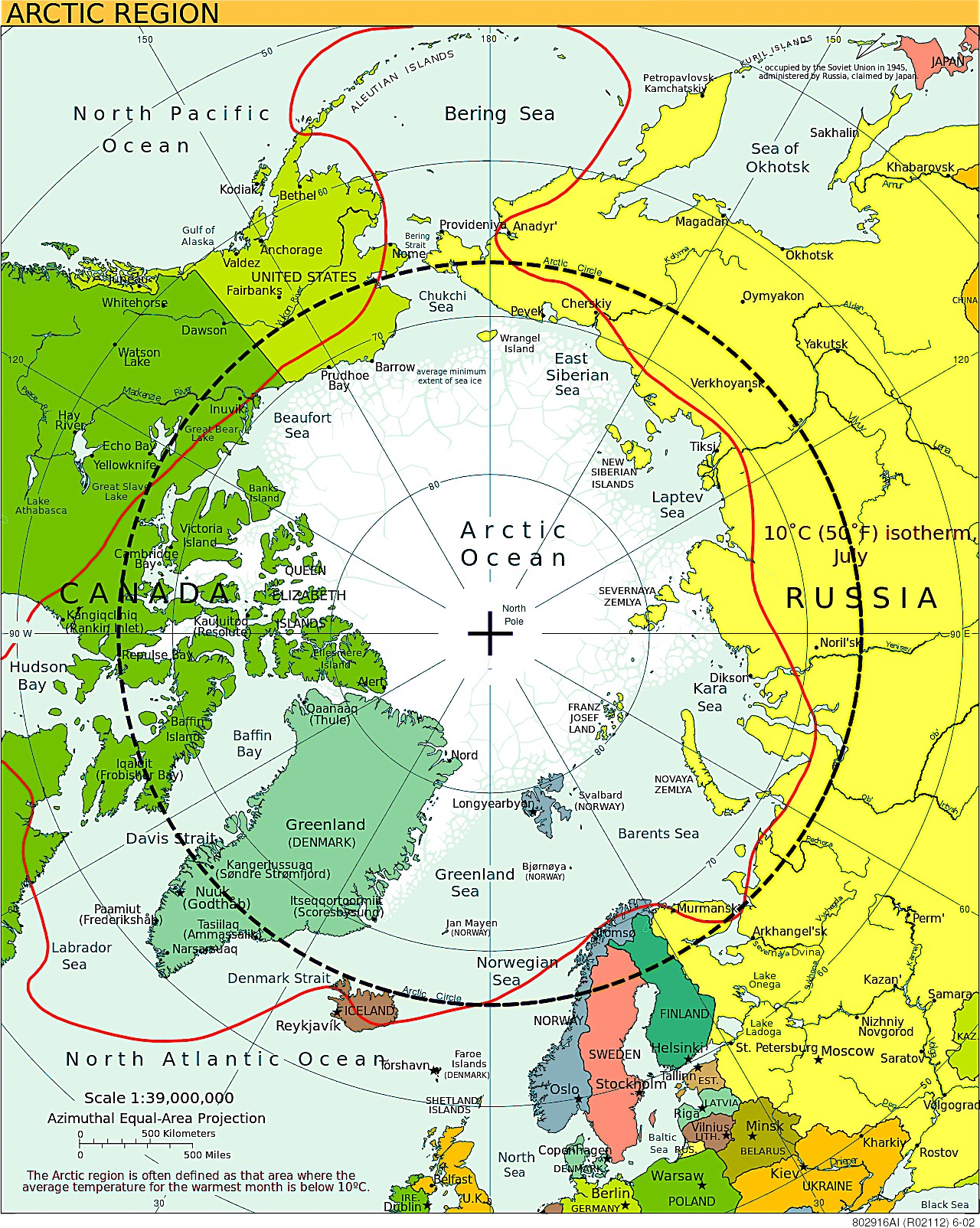
Looking at this map, you’ll notice two distinct lines crossing the northern regions.
The thin dashed line represents the familiar Arctic Circle, positioned at approximately 66°30′ N latitude. This astronomical boundary marks where the sun does not set on the day of the summer solstice, and does not rise on the day of the winter solstice.
But that bold red line? That’s the game-changer. It represents the 10°C isotherm, defined as the area where the average temperature in the warmest month (July) is below 10°C (50°F). And here’s where it gets interesting; this temperature-based boundary is what scientists actually use to define the Arctic.
Why Temperature Trumps Latitude
The 10°C July isotherm isn’t just an arbitrary number. This limit roughly coincides with the treeline and represents a change in growing conditions for plants.
In practical terms, it marks where you transition from forests to the characteristic Arctic landscape of tundra, permafrost, and hardy shrubs.
Think about it: if you’re a researcher studying ecosystems, Arctic foxes, or permafrost, what matters more, an invisible latitude line or the actual temperature that determines what can survive there?
The Geographic Mismatch
Here’s where your geography textbook might have misled you. Both the treeline and the 10°C isotherm are generally south of the Arctic Circle in the Western Hemisphere and north of the Arctic Circle in the Eastern Hemisphere.
In Alaska and northern Canada, the temperature-defined Arctic (red line) dips well south of the Arctic Circle, pulling in places like Fairbanks that experience true Arctic conditions despite being “officially” below the circle.
Meanwhile, in Scandinavia and northern Russia, the climate-based Arctic extends north of the traditional circle.
What This Means for Understanding Our Changing North
This distinction isn’t just academic nitpicking; it has real implications for understanding climate change and Arctic research. When scientists study Arctic warming, melting permafrost, or shifting wildlife populations, they’re looking at regions defined by actual environmental conditions, not arbitrary latitude lines.
The temperature-based definition also helps explain why some places feel surprisingly “Arctic” despite being south of the famous circle, while others within the circle might seem relatively temperate.
The Bottom Line
Next time someone mentions the Arctic, remember that nature doesn’t follow neat geometric lines. The real Arctic is defined by the harsh reality of temperature, or more specifically, places too cold for trees to grow during the brief summer months. It’s a boundary that shifts with the climate, making it both more complex and more meaningful than the static circle we learned about in school.
So while the Arctic Circle remains useful for astronomical and navigational purposes, when it comes to understanding the actual Arctic environment, follow the red line; this is where the real story unfolds.
Help us out by sharing this map: