Map from U.S. NOAA
You’ve probably pictured Hawaii as one big tropical paradise drenched in warm rain and lush greenery. The reality? It’s far more fascinating than that.
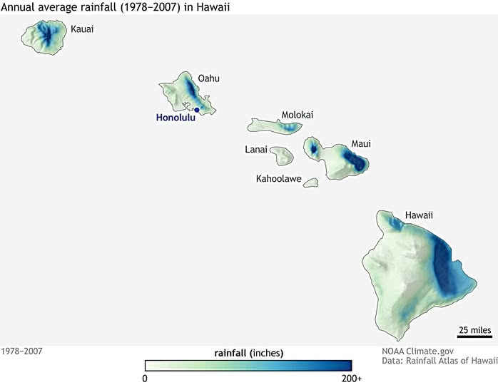
A Tale of Two Sides
This map, compiled from NOAA climate data spanning 1978 to 2007, reveals something stunning: rainfall in Hawaii is wildly uneven, and it all comes down to mountains and wind direction.
The trade winds blow moisture in from the northeast, and when that air hits a mountain, it rises, cools, and dumps its rain on one side. The other side stays bone dry.
Every island tells this story. On Maui, the deep blue patch on the eastern slopes of Haleakalā marks one of the wettest places on Earth, while the western and southern coasts receive a fraction of that moisture.
Same story on the Big Island of Hawaii, where the eastern flanks of Mauna Kea and Mauna Loa soak up enormous amounts of rain, while the Kona coast to the west sits in a classic rain shadow.
Oahu: Small Island, Huge Contrast
Honolulu sits on the dry southern shore of Oahu, which is exactly why it became such a popular city: pleasant, sunny weather nearly year-round.
Yet just a few miles north, the Ko’olau Mountains catch so much rainfall that stream flows are dramatic and vegetation becomes dense jungle almost instantly.
The Forgotten Islands
Kahoolawe, the small island south of Maui, shows almost no blue at all. It’s one of the driest places in the entire archipelago, historically stripped of vegetation and deeply affected by that lack of rainfall.
Lanai and Molokai sit somewhere in between, with pockets of higher rainfall inland but dry coastlines dominating.
What Kauai Is Hiding
Up in the northwest, Kauai looks modest on the map, but that deep blue core centered on Mount Waialeale is no accident. That summit regularly records among the highest annual rainfall totals anywhere on the planet, sometimes exceeding 400 inches per year.
The map caps its scale at 200 inches, so Kauai is essentially off the chart.
Why This Matters
Understanding Hawaiian rainfall patterns matters for agriculture, water supply, wildfire risk, and ecosystem health. As climate patterns shift, these gradients are changing too, with some wet areas getting wetter and dry zones expanding. The next time you book a Hawaiian vacation and wonder whether to pack an umbrella, check which side of the island your hotel sits on. The map has already answered that question for you.
Help us out by sharing this map: